The climate is constituted of a broad variety of meteorological conditions spread across a large geographic scale and varying topography, making generalizations difficult. The average weather conditions in a location over a lengthy period of time (30 years or more) are referred to as the climate.
There are many distinct types of climates on Earth. The climate is affected by a number of interconnected elements, including latitude, longitude, elevation, terrain, closeness to the sea, and wind direction.
Types of Climate
- Climate is the accumulation of weather conditions and fluctuations over a wide region over a long period of time.
- The condition of the atmosphere above a region at any one time is referred to as weather.
- Temperature, air pressure, wind, humidity, and precipitation are all factors of weather and climate.
- Climate change can be caused by either natural external forces (changes in solar output or changes in the Earth's orbit, natural internal processes of the climate system) or by human intervention.
- There are different types of climates:-
- Rainforest Climate (Tropical Evergreen Climate)
- Monsoon Climate
- Savanna Climate (Tropical Wet Dry Climate)
- Desert Climate
- Steppe Climate (Temperate Grassland Climate)
- Mediterranean Climate (Western Margin Climate)
- China Type Climate, Gulf Type Climate & Natal Type Climate
- British Type Climate (European Maritime Climate)
- Taiga Climate
- Laurentian Climate
- Tundra Climate (Polar Climate or Arctic Climate)
Tropical Evergreen Climate/ Rainforest Climate
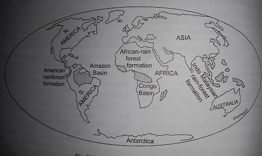
- Wet Tropical Climate Also known as the "Hot, Wet Equatorial Climate" or the "Equatorial Rainforest Climate."
- The areas are commonly referred to as "Equatorial Rainforests."
- Most of the time, it is between 5° N and 10° S of the Equator.
- Its biggest range is found in the Amazon, Congo, Malaysia, and the East Indies lowlands.
- Throughout the year, the temperature stays consistent.
- The monthly average temperature is consistently about 27° C, with very little variance.
- The daily temperature is moderated by cloudiness and heavy precipitation.
- Throughout the year, precipitation is abundant and evenly distributed.
- The annual average is consistently greater than 150 cm. In certain areas, the yearly average may reach 250 - 300 cm.
- There is no month that does not have rain (distinct dry season is absent). Most of the time, the monthly average is greater than 6 cm.
- The forests are not densely inhabited.
- The majority of primitive people in the forests live as hunter-gatherers, while the more advanced ones practice shifting cultivation.
- Despite the fact that the tropics have a high potential for wood resources, the commercial extraction is challenging.
- Multiple tree species coexist in a given region (trees do not grow inhomogeneous or pure stands), making economic exploitation challenging.
Monsoon Climate
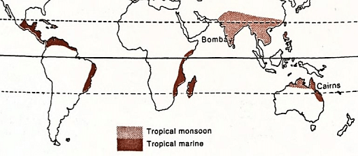
- Monsoons are a combination of land and sea winds on a much bigger scale.
- Monsoon climate differs from the equatorial wet climate in that it has distinct wet and dry seasons that are related to seasonal wind reversal.
- Floods are prevalent during the rainy season and droughts during the dry season.
- There are three seasons in a year: summer, winter, and rainy season.
- Occur between 5° and 30° north and south of the equator.
- Tropical monsoons occur on-shore [sea to land] in the summer and off-shore in the winter.
- They are most developed in India, Burma, Thailand, Laos, Cambodia, sections of Vietnam, south China, and northern Australia.
- The contrast in the speed of heating and cooling of land and water is the fundamental reason for monsoon climates.
- The waters, which warm up considerably more slowly, stay under quite high pressure.
- At the same time, the southern hemisphere is experiencing winter, and an area of high pressure has formed in Australia's continental heartland.
- Winds sweep forth as the South-East Monsoon to Java, then cross the equator and are drawn towards the continental low-pressure system, eventually reaching the Indian subcontinent as the South-West Monsoon.
- In the winter, the condition is reversed.
- Summer temperatures vary from 30° C to 45° C. The average summer temperature is around 30°C.
- In the winter, the temperature ranges from 15 to 30 degrees Celsius, with a typical temperature of 20 to 25 degrees Celsius.
- The annual mean rainfall is between 200 and 250 cm. It is approximately 350 cm in certain areas.
- To sustain the high population, most of the monsoon forest has been removed for cultivation.
- The main source of income is subsistence agriculture. The most significant staple crop is rice.
- Irrigation of water from rivers, canals, dams, or wells is widely employed in rice-growing countries.
- Other food crops, such as maize, millet, sorghum, wheat, gram, and beans, are secondary insignificance.
Savanna Climate
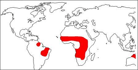
- This climate features alternate rainy and dry seasons, comparable to a monsoon climate, but with significantly less yearly rainfall. Floods and droughts are common occurrences.
- Monsoon climatic zones have very distinct vegetation, fauna, and human life. It is restricted to the tropics and is most developed in Sudan, thus the name Sudan Climate.
- It is a type of environment that exists between tropical rainforests and scorching deserts.
- The average annual rainfall varies from 80 to 160 cm. Rainfall diminishes as one moves farther from the equator.
- The average yearly temperature is higher than 18° C.
- For lowland sites, the monthly temperature ranges between 20° C to 32° C.
- The hottest months do not correlate with the hottest days of the year (for example, June in the northern hemisphere), but rather with the start of the rainy season, which occurs around April in the Northern Hemisphere and October in the Southern Hemisphere.
- Tallgrass and low trees characterize the savanna landscape.
- Grasslands are sometimes known as 'bush-veld.'
- The trees are deciduous, meaning they shed their leaves during the chilly, dry season to minimize excessive water loss through transpiration.
- The savanna is home to two types of animals: grass-eating herbivorous animals and flesh-eating carnivorous animals.
- The savanna is renowned as a "big game country," since people from all over the world trap or kill thousands of animals there each year.
Desert Climate
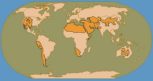
- Deserts are areas where evaporation outnumbers precipitation.
- There are primarily two types: hot deserts, such as the Saharan type, and temperate deserts, such as the Gobi.
- The aridity of the hot deserts is mostly caused by the impacts of off-shore Trade Winds, which is why they are also known as Trade Wind Deserts.
- The world's major hot deserts are found on the western shores of continents between latitudes 15° and 30°N. and S.
- They include the Sahara Desert (3.5 million square miles), the Great Australian Desert, the Arabian Desert, the Iranian Desert, the Thar Desert, the Kalahari Desert, and the Namib Desert.
- Temperate deserts are rainless due to continentality or the rain-shadow effect.
- Many of the mid-latitude deserts are found on plateaus and are located a long distance from the sea.
- These include the Central Asian deserts of Ladakh, Kyzyl Kum, Turkestan, Taklimakan, and the Gobi, as well as drier areas of the Great Basin Desert in the western United States and Argentina's the Patagonian Desert.
- In the hot deserts, there is no winter season, and the average summer temperature is approximately 30°C.
- In 1922, the maximum temperature recorded was 57.77° C in A1 Azizia, Libya.
- These interior basins are hundreds of kilometers from the sea and are surrounded by steep mountains. As a result, the rain-bearing winds have cut them off. Both hot and mid-latitude deserts have xerophytic, or drought-resistant, plants.
- Cacti, prickly shrubs, long-rooted wiry grasses, and scattered dwarf acacias are examples of this.
- Except when there is adequate groundwater to maintain clusters of date palms, trees are scarce.
Steppe Climate
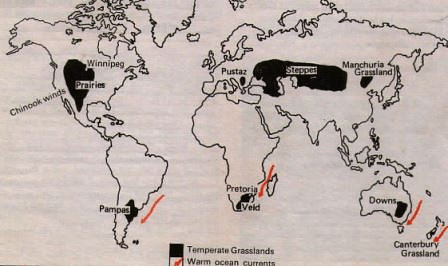
- They are located in the continents' interiors.
- Located in the Westerly wind belt, the mid-latitudes, or the temperate zone.
- Due to the continentality of grasslands, they are almost entirely devoid of trees.
- They are known as the Steppes in Eurasia and extend eastward from the Black Sea to the foothills of the Altai Mountains.
- The climate is continental, with temperature extremes. Summer and winter temperatures differ substantially.
- Summers are scorching, while winters are very cold. Summers are quite hot, with temperatures ranging from 18 to 20 degrees Celsius.
- The average rainfall is 45 cm, however, this ranges from 25 cm to 75 cm depending on location.
- The wettest months are June and July.
- On the eastern slopes of the Rockies in Canada and the United States, a local wind is known as the Chinook, comparable to the Fohn in Switzerland, blows south-westerly to the Prairies and has a significant impact on the local meadows.
- The most notable distinction between steppes and tropical savannas is that steppes are almost entirely devoid of trees and have significantly shorter grasses.
- Grasses are tall, fresh, and nutrient-dense plants. This is typical of grass in North American wheatlands, rich black soil or chernozem portions of Russian Ukraine, and better-hydrated areas of the Asiatic Steppes.
- As one moves farther north, an increase in precipitation creates a transitional zone of forested steppes, with some conifers appearing gradually.
Mediterranean Climate
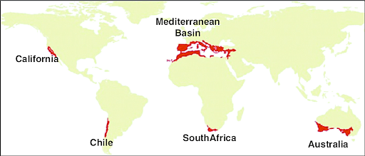
- The western section of continental masses, between 30° and 45° north and south of the equator.
- The changing of the wind belts is the primary cause of this sort of climate.
- The Mediterranean Sea has the most of this sort of 'winter rain climate,' thus the term Mediterranean Climate.
- The average yearly precipitation ranges between 35 and 90 cm.
- The warmest month's temperature is more than or equal to 100 degrees Celsius. The coldest month's temperature is less than 180 C but more than –30 C.
- Due to the cooling effect of water bodies, the climate is not severe.
- The belt of influence of the Westerlies is pushed a bit polewards in summer when the sun is overhead at the Tropic of Cancer.
- As a result, rain-bearing winds are unlikely to reach the Mediterranean.
- When the Westerlies shift equatorward in the winter, the Mediterranean lands receive the majority of their precipitation.
- The prevalent on-shore Westerlies in the northern hemisphere bring a lot of cyclonic rain from the Atlantic.
- Rain falls in heavy showers only on a few days a week, with brilliant sunny intervals in between. Another distinctive element of the Mediterranean winter rain is this.
- Small, broad-leaved trees are widely scattered and never grow to be very tall.
- Mediterranean landscapes are characterized by a lack of shadow.
- Heat, dry air, heavy evaporation, and lengthy droughts are all battlegrounds for plants. Wheat is the most important food crop. The second most common cereal is barley.
- The milder environment of the alpine meadows supports a few sheep, goats, and cattle. Viticulture has long been associated with the Mediterranean.
China Type Climate, Gulf Type Climate & Natal Type Climate
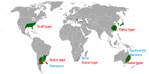
- On the east coast of both hemispheres, between 20° and 35° N and S latitude (warm temperate latitudes just outside the tropics).
- In most sections of China, a temperate monsoon or China-type climate prevails. The climate may also be found in Japan's southern regions.
- The Gulf of Mexico climate is found in the south-eastern United States when continental warmth in the summer causes an influx of air from the colder Atlantic Ocean.
- New South Wales (Australia), Natal (South Africa), and the Paraguay-Uruguay basin have Natal climates.
- The Natal type differs from the temperate monsoon or China types in that it receives rain all year from on-shore Trade Winds.
- Summers are hot and humid, and winters are cold and dry. The average monthly temperature fluctuates between 4 and 25 degrees Celsius and is heavily influenced by coastal influences.
- The infiltration of frigid air (Polar Vortex) from the continental regions can send the temperature down to a freezing point on rare occasions. Rainfall is moderate, ranging from 60 to 150 centimeters.
- Summer rain occurs from conventional sources or as orographic rain, whereas winter rain comes from depressions in persistent showers.
- The regions are influenced by moist, marine airflow from subtropical anticyclonic cells during the summer.
- It supports lush vegetation. Both evergreen broad-leaved woods and deciduous trees grow in the lowlands.
- Conifers such as pines and cypresses, which are essential softwoods, may be found in the highlands.
- Oak, camphor, and other valuable trees may be found in China's and southern Japan's woods.
British Type Climate
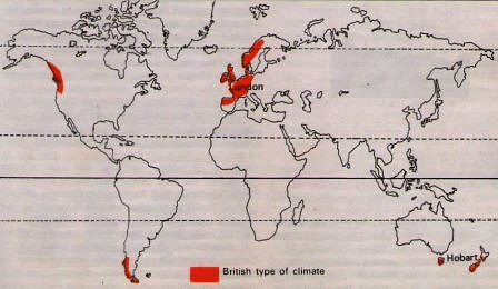
- The influence is most noticeable in and around the United Kingdom.
- The climatic belt runs deep inland into North-West Europe's lowlands, including northern and western France, Belgium, the Netherlands, Denmark, western Norway, and north-western Iberia.
- The Westerlies have a constant impact on the cold temperate western edges throughout the year. There is a tendency for rainfall to peak in the autumn or winter. In the winter, there is light snowfall.
- Although ports never freeze, frosts do form on chilly nights. Seasons have unique characteristics.
- Furthermore, the climate is ideal for maximal human performance.
- The average yearly temperature is between 5 and 15 degrees Celsius.
- The winters here are unusually mild. Because of the warming influence of the North Atlantic Drift, this is the case.
- The British climate provides ample rainfall throughout the year, with a little trend toward a winter maximum.
- Westerlies provide the most rain on the western edges.
- In the tropics, this sort of climate, with its four different seasons, is glaringly lacking. This climate type's native vegetation is deciduous woodland.
- In the winter, the trees lose their leaves. This is an adaptation to shield them from the cold and snow of winter.
- A wide variety of grains, fruits, and root crops are grown, primarily for domestic use rather than export. Potatoes are one of the most important food crops in the domestic economy of cold temperate climates.
- For millions of people, it is a basic diet to supplement wheat or bread.
Taiga Climate
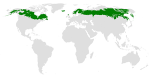
- Due to its large east-west span, it is exclusively found in the northern hemisphere. Because of the narrowness of the high latitudes, it is not seen in the southern hemisphere.
- It runs over central Canada, certain portions of Scandinavian Europe, and the majority of central and southern Russia in a continuous band. [From 50 to 70 degrees North].
- Summers are short and pleasant, averaging 20-25 degrees Celsius, but winters are lengthy and bitterly cold, averaging 30-40 degrees Celsius below freezing.
- The Siberian Climate has the widest annual temperature variation [about 50-60 °C in Siberia].
- The amount of precipitation falls evenly throughout the year, with a peak in the summer. Because mean temperatures remain consistently below freezing in the winter, precipitation falls in the form of snow.
- Evergreen coniferous forest dominates the landscape.
- Conifers thrive in this sort of subArctic climate because they require minimal rainfall.
- The taiga (a Russian name for coniferous forest) in Siberia is the largest single swath of coniferous forest.
- Sweden and Finland are two European nations that share comparable climates and woodlands.
- The amount of precipitation falls evenly throughout the year, with a peak in the summer. Because mean temperatures remain consistently below freezing in the winter, precipitation falls in the form of snow. Evergreen coniferous forest dominates the landscape.
- Conifers thrive in this sort of subArctic climate because they require minimal rainfall.
- The taiga in Siberia is the largest single swath of coniferous forest.
- Sweden and Finland are two European nations that share comparable climates and woodlands.
Laurentian Climate
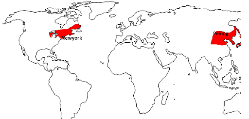
- The Laurentian climate can only be found in two places, and exclusively in the northern hemisphere.
- North-eastern North America, comprising eastern Canada, the northeastern United States, and Newfoundland, has a Laurentian climate. This is also known as the North American area.
- Winters are chilly and dry, and summers are hot and humid.
- Winter temperatures are below freezing, and snowfall is a natural occurrence. Rainfall occurs throughout the year, with a peak in the summer. The annual rainfall varies between 75 and 150 cm.
- Cool temperate woodland dominates the landscape.
- The abundant rains, hot summers, and wet air from fog all encourage tree development. The most popular exports are timber and seafood.
- Much of the coniferous forest of fir, spruce, and larch is heavily exploited.
- The most major economic enterprise is lumbering, which includes the timber, paper, and pulp industries. Because of the long and harsh winters, agriculture is less essential.
- Due to the convergence of the warm Kuroshio and the cold Oyashio currents, the continental shelf around Japan's islands is rich in plankton and provides good breeding grounds for various sorts of fish.
Tundra Climate
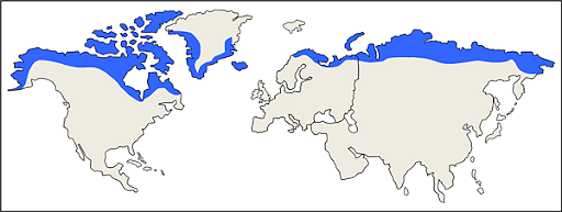
- North of the Arctic Circle and south of the Antarctic Circle are where tundra Climate can be found.
- Greenland and Antarctica's ice caps are restricted to the highlands and high latitude areas.
- A relatively low mean yearly temperature characterizes the tundra environment.
- Temperatures can drop to 40 – 50 °C below freezing in the middle of winter.
- Snow and sleet are the most common forms of precipitation. Convectional rainfall is almost non-existent. In the tundra, there are no trees.
- Mosses, lichens, and other low-level vegetation can be seen here and there.
- The climate on the coastal lowlands is slightly more favorable.
- Reindeer moss and resistant grasses thrive in the coastal lowlands, providing the only source of pasturage for the animals.
- Berry-bearing shrubs and Arctic flowers bloom during the limited summer.
- The tundra's human activities are mostly limited to the coast. A semi-nomadic lifestyle is practiced.
- The Eskimos dwell in Greenland, northern Canada, and Alaska.
Conclusion
Natural external forcings (changes in solar output or changes in the Earth's orbit, natural internal climate system processes) or human involvement can both cause climate change. A variety of linked factors influence the climate, including latitude, longitude, elevation, topography, proximity to the sea, and wind direction. Climates differ in different places of the world. Every day is hot and wet in certain regions of the world.