DRAINAGE SYSTEM - NCERT EXERCISES
1. नीचे
दिए गए चार विकल्पों में से सही उत्तर को चुनिए :
(i) निम्नलिखित में से कौन-सी नदी ‘बंगाल का शोक’ के नाम से जानी जाती थी?
(क) गंडक
(ख) कोसी
(ग) सोन (घ) दामोदर
Ans. (घ) दामोदर
Choose
the right answer from the four alternatives given below.
(i)
Which one of the following rivers was known as the ‘Sorrow of Bengal’?
(a)
The Gandak (c) The Kosi
(b)
The Son (d) The Damodar
Ans. (d) The
Damodar
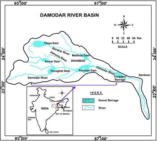 |
| The Damodar - known as the ‘Sorrow of Bengal’ |
(ii) निम्नलिखित में से किस नदी की द्रोणी भारत में सबसे बड़ी है?
(क) सिंधु
(ख) बह्मपुत्र
(ग) गंगा (घ) कृष्णा
Ans. (ग) गंगा
(ii)
Which one of the following rivers has the largest river basin in India?
(a)
The Indus (c) The Ganga
(b)
The Brahmaputra (d) The Krishna
Ans. (c) The Ganga
 |
| the largest river basin in India |
 |
| the largest river basin in India |
(iii) निम्नलिखित में से कौन-सी नदी पंचनद में शामिल नहीं है?
(क) रावी (ख)
सिंधु
(ग) चेनाब (घ) झेलम
Ans. (ख) सिंधु
(iii)
Which one of the following rivers is not included in ‘Panchnad’?
(a)
The Ravi (b) The Indus
(c)
The Chenab (d) The Jhelum
Ans. (b) The Indus
 |
| The Indus |
(iv) निम्नलिखित में से कौन-सी नदी भ्रंश घाटी में बहती है?
(क) सोन (ख)
यमुना
(ग) नर्मदा (घ) लूनी
Ans. (ग) नर्मदा
(iv)
Which one of the following rivers flows in a rift valley?
(a)
The Son (b) The Yamuna
(c)
The Narmada (d) The Luni
Ans. (c) The
Narmada
 |
| The Narmada River |
(v) निम्नलिखित में से कौन-सा अलकनंदा व भागीरथी का संगम स्थल है?
(क) विष्णु प्रयाग (ख)
रूद्र प्रयाग
(ग) कर्ण प्रयाग (घ) देव प्रयाग
Ans. (घ) देव प्रयाग
(v)
Which one of the following is the place of confluence of the Alaknanda and the
Bhagirathi?
(a)
Vishnu Prayag (c) Karan Prayag
(b)
Rudra Prayag (d) Deva Prayag
Ans. (d) Deva Prayag
 |
| Deva Prayag |
2. निम्न में अंतर स्पष्ट करें :
State
the differences between the following.
(i)
नदी द्रोणी और जल-संभर
Ans.
किसी नदी और
उसकी सहायक नदियों द्वारा जल बहने वाले क्षेत्र को जल ग्रहण बेसिन या नदी
द्रोणी कहा जाता है। एक नदी द्रोणी को दूसरे से अलग करने वाली सीमा रेखा को जल
विभाजक (वाटर डिवाइड) के रूप में जाना जाता है। एक नदी, एक विशिष्ट क्षेत्र से
एकत्रित पानी को बहा ले जाती है, जिसे उसका 'जलग्रहण क्षेत्र'
कहा जाता है। बड़ी नदियों के जलग्रहण क्षेत्रों को नदी बेसिन कहा
जाता है जबकि छोटे नालों और धाराओं को अक्सर वाटरशेड कहा जाता है। हालाँकि,
नदी बेसिन और वाटरशेड के बीच थोड़ा-सा अंतर है। जलसंभर क्षेत्र छोटे
होते हैं जबकि बेसिन बड़े क्षेत्रों को कवर करते हैं।
(i)
River Basin and Watershed
An area
drained by a river and its tributaries is called a drainage basin. The
boundary line separating one drainage basin from the other is known as the
watershed (Water Divide). A river drains the water collected from a
specific area, which is called its ‘catchment area’. The catchments of
large rivers are called river basins while those of small rivulets and
rills are often referred to as watersheds. There is, however, a slight
difference between a river basin and a watershed. Watersheds are small in area
while the basins cover larger areas.
 |
| Drainage basin |
(ii) वृक्षाकार और जालीनुमा अपवाह प्रारूप Dendritic and Trellis drainage pattern
Ans.
(A) वृक्षाकार अपवाह प्रारूप:
-
पेड़ की शाखाओं से मिलता जुलता जल निकासी
पैटर्न को "वृक्षाकार अपवाह प्रारूप "
के रूप में जाना जाता है। भारत के उत्तरी मैदान की नदियाँ और उनकी सहायक नदियाँ
इसके उदाहरण हैं, जैसे - सिंधु, गंगा और ब्रह्मपुत्र नदियाँ।
Dendritic
drainage pattern: - The drainage
pattern resembling the branches of a tree is known as “dendritic drainage
pattern”. The rivers and their tributaries of the northern plain of India
are the examples of it, likely The Indus, The Ganga and the Brahamputra Rivers.
 |
| Dendritic drainage pattern |
(B) जालीनुमा अपवाह प्रारूप: -
जब नदियों की प्राथमिक सहायक नदियाँ एक
दूसरे के समानांतर बहती हैं और माध्यमिक सहायक नदियाँ समकोण पर उनसे जुड़ती हैं,
तो यह प्रारूप ‘जालीनुमा अपवाह प्रारूप ' के रूप में जाना जाता है।
Trellis
drainage pattern: - When the primary
tributaries of rivers flow parallel to each other and secondary tributaries
join them at right angles, the pattern is known as ‘trellis drainage pattern’.
 |
| Trellis drainage pattern |
(iii) अपकेंद्रीय और अभिकेंद्रीय अपवाह प्रारूप Radial and Centripetal drainage pattern
Ans.
(A) अपकेंद्रीय अपवाह प्रारूप: -
जब नदियाँ किसी पहाड़ी से निकलती हैं और
सभी दिशाओं में बहती हैं, तो जल निकासी पैटर्न को ‘अपकेंद्रीय अपवाह
प्रारूप '
के रूप में जाना जाता है। अमरकंटक श्रेणी से निकलने वाली नदियाँ
(नर्मदा, महानदी और सोन नदी) इसका अच्छा उदाहरण प्रस्तुत
करती हैं।
Radial
drainage pattern: -When
the rivers originate from a hill and flow in all directions, the drainage
pattern is known as ‘radial drainage pattern’. The rivers (Narmada,
Mahanadi and Son River) originating from the Amarkantak range present a
good example of it.

Radial drainage pattern
(B) अभिकेंद्रीय अपवाह प्रारूप: - जब नदियाँ अपना पानी सभी दिशाओं से किसी झील या गर्त में छोड़ती हैं, तो इस पैटर्न को 'सेंट्रिपेटल ड्रेनेज पैटर्न' के रूप में जाना जाता है।
Centripetal
drainage pattern:- When the rivers
discharge their waters from all directions to in a lake or depression, the
pattern is known as ‘centripetal drainage pattern’.
 |
| Centripetal drainage pattern |
(iv) डेल्टा और ज्वारनदमुख Delta and Estuary
Ans.
डेल्टा:- समुद्र या
झील में गिरने से पहले, नदी कई सहायक नदियों में विभाजित हो जाती है और अपने साथ लायी गयी तलछट को
एक त्रिकोण जैसी आकृति में जमा करती है जिसे डेल्टा कहा जाता है।
नोट:- 'डेल्टा' शब्द का प्रयोग दुनिया में सबसे पहले यूनानी दार्शनिक हेरोडोटस ने नील नदी
द्वारा जमा की गई स्थलाकृतियों को संदर्भित करते हुए किया था। गंगा-ब्रह्मपुत्र
नदी द्वारा निर्मित सुंदरवन डेल्टा (भारत-बांग्लादेश में) विश्व का सबसे बड़ा
(125000 वर्ग किमी.) डेल्टा है।
Delta:- Before falling into a sea or lake,
the river divides into several distributaries and deposits the sediments
carried with them into a triangle-like shape called a delta.
Note:- The word ‘delta’ was first used in the world
by the Greek philosopher Herodotus, referring to the landforms deposited
by the Nile. The Sundarban delta (in India-Bangladesh) formed by the
Ganges-Brahmaputra river is the largest (125000 sq. km.)
delta in the world.
 |
| Delta |
ज्वारनदमुख:- ज्वारनदमुख वह क्षेत्र है जहां मीठे पानी की नदी या जलधारा समुद्र से मिलती है। जब ताज़ा पानी और समुद्री पानी मिलते हैं, तो पानी खारा या थोड़ा नमकीन हो जाता है। ज्वारनदमुख को खाड़ी, लैगून, साउन्ड या स्लाउ भी कहा जा सकता है।
नोट - सेंट लॉरेंस
नदी, जो ग्रेट लेक्स को अटलांटिक महासागर से जोड़ती है, दुनिया
का सबसे बड़ा ज्वारनदमुख है। सेंट लॉरेंस नदी लगभग 1,197
किलोमीटर (744 मील) लंबी है।
Estuary:-
An
estuary is an area where a freshwater river or stream meets the ocean. When
freshwater and seawater combine, the water becomes brackish, or slightly salty.
An estuary may also be called a bay, lagoon, sound, or slough.
 |
| Estuary |
Note - St. Lawrence River, which connects the Great Lakes to the Atlantic Ocean, is the world's largest estuary. The St. Lawrence River is about 1,197 kilometers (744 miles) long.
Source: https://education.nationalgeographic.org/resource/estuary
3. निम्नलिखित प्रश्नों के उत्तर लगभग 30 शब्दों में दें।
Answer
the following questions in about 30 words.
(i) भारत में नदियों को आपस में जोड़ने के सामाजिक-आर्थिक लाभ क्या हैं?
Ans. बरसात के मौसम में नदियों का अधिकांश
पानी बर्बाद हो जाता है। इसी तरह जब देश के एक हिस्से में बाढ़ तबाही मचा रही है
तो उसी वक्त देश का दूसरा हिस्सा सूखे की समस्या से जूझ रहा होता है। सूखे और बाढ़
की समस्या के समाधान के लिए नदी जोड़ो परियोजना पर काम चल रहा है।
भारत में
नदी घाटियों को जोड़ने की इस योजना को राष्ट्रीय जल ग्रिड कहा जाता है।
इस अवधारणा
का मुख्य उद्देश्य नदियों द्वारा समुद्र में ले जाये जाने वाले बहुमूल्य जल की
उचित योजना बनाना है। इसके तहत जल समृद्ध और जल की कमी वाले क्षेत्रों को भौगोलिक
दृष्टि से लिंक नहरों से जोड़ा जाएगा। जल संसाधनों के इस आदान-प्रदान से संतुलन
स्थापित होगा। उदाहरण के लिए, गंगा-कावेरी लिंक गंगा नदी से अतिरिक्त पानी को
कावेरी नदी बेसिन तक ले जाएगा। इसी तरह चंबल राजस्थान लिंक के जरिए चंबल नदी का
पानी राजस्थान के सूखाग्रस्त इलाकों तक पहुंचाया जाएगा।
सुप्रीम
कोर्ट ने भी केंद्र सरकार को 2012 तक देश की प्रमुख नदियों को जोड़ने का ऐतिहासिक
निर्देश दिया था, जिस पर अभी भी काम चल रहा है।
राष्ट्रीय
जल ग्रिड अवधारणा के मुख्य बिंदु निम्नलिखित हैं:-
1.
सूखाग्रस्त क्षेत्रों में सिंचाई हेतु जल आपूर्ति सुनिश्चित करना।
2. देश के
विभिन्न भागों में बने कृत्रिम जलाशयों में अतिरिक्त वर्षा जल को संग्रहित करना।
3. लिंक
नहरों के माध्यम से शुष्क और अर्ध-शुष्क क्षेत्रों में अतिरिक्त 350 लाख हेक्टेयर
भूमि की सिंचाई करना।
4. पठारी
क्षेत्रों में जलाशयों एवं बाँधों का निर्माण एवं विद्युत उत्पादन।
(i)
What are the socio-economic advantages of inter-linking of rivers in India?
Ans. Most of
the water of the rivers is wasted during the rainy season. Similarly, when
floods are causing havoc in one part of the country, at the same time another
part of the country is facing the problem of drought. To solve the problems of
drought and flood, work is going on River Interlinking Project.
This scheme for connecting river basins in India is called National
Water Grid.
The main objective of this concept is to make proper planning of the valuable water that is carried by rivers to the sea. Under this, the water-rich and water-scarce areas will be connected geographically by link canals. A balance will be established by this exchange of water resources. For example, the Ganga-Cauvery link will carry additional water from the river Ganga to the Cauvery river basin. Similarly, the water of Chambal River will be transported to the drought-prone areas of Rajasthan through Chambal Rajasthan Link.
The Supreme Court had also given historic instructions to the
central government to interlink the major rivers of the country by 2012, on which work is
still going on.
Key Points of the National Water Grid Concept are
following:-
1. Ensuring water supply for irrigation in drought
prone areas.
2. To store excess rain water in artificial
reservoirs built in different parts of the country.
3. To irrigate an additional 350 lakh hectares of land in arid and semi-arid
areas through link canals.
4. Construction of reservoirs and dams in plateau
areas and generation of electricity.
(ii) प्रायद्वीपीय नदी के तीन लक्षण लिखें।
Ans.
1.
प्रायद्वीपीय पठार की नदियाँ छोटी हैं।
2. इनका नदी
बेसिन एवं जलग्रहण क्षेत्र अपेक्षाकृत छोटा है।
3. दक्षिण
भारत की नदियाँ मुख्यतः मानसूनी वर्षा पर निर्भर हैं और गर्मियों में सूख जाती
हैं।
(ii)
Write three characteristics of the Peninsular River.
Ans.
1. The rivers
of the Peninsular Plateau are small.
2. Their
river basin and catchment area are relatively small.
3. The rivers
of South India are mainly dependent on monsoon rains and dry up in summer.
4. निम्नलिखित प्रश्नों के उत्तर 125 शब्दों से अधिक में न दें।
Answer
the following questions in not more than 125 words.
(i) उत्तर भारतीय नदियों की महत्त्वपूर्ण विशेषताएँ क्या हैं? ये प्रायद्वीपीय नदियों से किस प्रकार भिन्न हैं?
Ans.
हिमालय
पर्वत की नदियाँ:-
1. हिमालय
पर्वत की नदियाँ लम्बी हैं।
2. उनके
बेसिन और जलग्रहण क्षेत्र बहुत बड़े हैं।
3. ये
नदियाँ बारहमासी हैं, क्योंकि इनमें बर्फ पिघलने और वर्षा के कारण वर्ष भर पानी रहता है।
4. हिमालय
की नदियाँ विशाल घाटियों का निर्माण करती हैं और अपना मार्ग भी बदलती हैं।
5. हिमालय
की नदियाँ सिंचाई और नौकायन के लिए उपयोगी हैं।
6. हिमालय
की नदियों द्वारा निर्मित डेल्टा बड़े हैं।
प्रायद्वीपीय
पठार की नदियाँ:-
1.
प्रायद्वीपीय पठार की नदियाँ छोटी होती हैं।
2. उनके पास
छोटे बेसिन और जलग्रहण क्षेत्र हैं।
3.
प्रायद्वीपीय पठार की नदियाँ मौसमी हैं, क्योंकि इन्हें मानसूनी
वर्षा से पानी मिलता है।
4.
प्रायद्वीपीय पठार की नदियाँ घाटियों से होकर बहती हुई अपेक्षाकृत सीधे रास्ते पर
चलती हैं।
5.
प्रायद्वीपीय पठार की लगभग सभी नदियाँ पठार से उतरते समय झरने बनाती हैं जिनका
उपयोग जल विद्युत उत्पादन के लिए किया जाता है।
6.
प्रायद्वीपीय नदियों द्वारा निर्मित डेल्टा छोटे होते हैं।
(i)
What are the important characteristic features of north Indian rivers? How are these
different from Peninsular Rivers?
Ans.
Rivers of Himalaya Mountains: -
1. The rivers of the Himalaya Mountains are
longer.
2. Their basins and catchment areas are much
larger.
3. These rivers are perennial, because they get
water throughout the year due to melting snow and rain.
4. The Himalayan Rivers form giant gorges and also
change their course.
5. The Himalayan Rivers are useful for irrigation
and boating.
6. The deltas formed by the Himalayan Rivers are
large.
Rivers of Peninsular Plateau: -
1. The rivers of the peninsular plateau are
shorter.
2. They have small basins and catchment areas.
3. The rivers of the Peninsular Plateau are
seasonal, because they get water by monsoon rain.
4. The rivers of the peninsular plateau follow a
relatively straight path as they flow through the valleys.
5. Almost all the rivers of the peninsular
plateau, while descending from the plateau, form waterfalls which are used for
hydro power generation.
6. The deltas formed by peninsular rivers are
small.
(ii) मान लीजिए आप हिमालय के गिरिपद के साथ-साथ हरिद्वार से सिलीगुड़ी तक
यात्रा कर रहे हैं। इस मार्ग में आने वाली मुख्य नदियों के नाम बताएँ। इनमें से
किसी एक नदी की विशेषताओं का भी वर्णन करें।
Ans.
हिमालय के
गिरिपद में हरिद्वार से सिलीगुड़ी तक यात्रा करते समय, हम रामगंगा, गोमती, शारदा और करनाली (घाघरा), गंडक, कोसी तथा सिलीगुड़ी के पास महानदी को पार करके
आएंगे।
कोसी एक प्राचीन
नदी है जिसका उद्गम तिब्बत में माउंट एवरेस्ट के उत्तर में है, जहाँ से इसकी मुख्य धारा
अरुण निकलती है। नेपाल में मध्य हिमालय को पार करने के बाद, यह
पश्चिम से सोन कोसी और पूर्व से तमूर कोसी से मिलती है। अरुण नदी से मिलकर यह सप्त
कोसी का निर्माण करती है।
कोसी नदी, जिसे 'बिहार का शोक' भी कहा जाता है, बार-बार अपना रास्ता बदलने के लिए कुख्यात रही है। कोसी अपने ऊपरी प्रवाह से
भारी मात्रा में अवसाद लाती है और मैदानों में जमा करती है। मार्ग अवरुद्ध हो जाता
है, और परिणामस्वरूप, नदी अपना मार्ग बदल
लेती है।
(ii)
Suppose you are travelling from Haridwar to Siliguri along the foothills of the
Himalayas. Name the important rivers you will come across. Describe the characteristics
of any one of them.
Ans. While
travelling from Haridwar to Siliguri along the foothills of the Himalayas, we
shall come across Ramganga, Gomti, Sharda and Karnali (Ghaghara), Gandak,
Kosi and Mahanadi near siliguri.

The Ganga River Basin
The Kosi is an antecedent river with its source to the north of Mount Everest in Tibet, where its main stream Arun rises. After crossing the Central Himalayas in Nepal, it is joined by the Son Kosi from the West and the Tamur Kosi from the east. It forms Sapt Kosi after uniting with the river Arun.
River Kosi, also know
as the ‘sorrow of Bihar’, has been notorious for frequently changing its
course. The Kosi brings huge quantity of sediments from its upper reaches and
deposits it in the plains. The course gets blocked, and consequently, the river
changes its course.
परियोजना/क्रियाकलाप Project/Activity
परिशिष्ट-III का अध्ययन करें और
निम्नलिखित प्रश्नों के उत्तर दें।
Study
the Appendix III and answer the following questions.
(i) देश में किस नदी के जलग्रहण क्षेत्र का अनुपात सबसे ज़्यादा है?
Ans.
गंगा अपने
बेसिन (जलग्रहण क्षेत्र) और सांस्कृतिक महत्व दोनों ही दृष्टि से भारत की सबसे
महत्वपूर्ण नदी है। यह उत्तराखंड के उत्तरकाशी जिले में गौमुख (3,900 मीटर) के पास
गंगोत्री ग्लेशियर से निकलती है। यहां इसे भागीरथी के नाम से जाना जाता है।
यह मध्य और लघु हिमालय को संकरी घाटियों में काटती है। देवप्रयाग में भागीरथी
अलकनंदा से मिलती है; इसके बाद इसे गंगा के नाम से
जाना जाता है। अलकनंदा का स्रोत बद्रीनाथ के ऊपर सतोपंथ ग्लेशियर में है। अलकनंदा
में धौली और विष्णु गंगा शामिल हैं जो जोशीमठ या विष्णु प्रयाग में मिलती
हैं। अलकनंदा की अन्य सहायक नदियाँ जैसे पिंडर कर्ण प्रयाग में इससे मिलती
हैं जबकि मंदाकिनी या काली गंगा रुद्र प्रयाग में इससे मिलती हैं। गंगा
हरिद्वार में मैदानी क्षेत्र में प्रवेश करती है। यहां से, यह
पहले दक्षिण की ओर बहती है, फिर दक्षिण-पूर्व और पूर्व की ओर
बहती है और दो सहायक नदियों, भागीरथी और पद्मा में विभाजित
हो जाती है। नदी की लंबाई 2,525 किमी है। यह उत्तराखंड (110
किमी) और उत्तर प्रदेश (1,450 किमी), बिहार
(445 किमी) और पश्चिम बंगाल (520 किमी) द्वारा साझा किया जाता है। अकेले भारत में
गंगा बेसिन लगभग 8.6 लाख वर्ग किमी क्षेत्र में फैला हुआ है। गंगा नदी प्रणाली
भारत में सबसे बड़ी है, जिसमें उत्तर में हिमालय और दक्षिण
में प्रायद्वीप से क्रमशः कई बारहमासी और गैर-बारहमासी नदियाँ निकलती हैं। सोन
इसकी प्रमुख दाहिने किनारे की सहायक नदी है। बाएं किनारे की महत्वपूर्ण सहायक
नदियाँ रामगंगा, गोमती, घाघरा, गंडक, कोसी और महानंदा हैं। नदी अंततः सागर द्वीप के
पास बंगाल की खाड़ी में गिरती है और ब्रह्मपुत्र नदी के साथ दुनिया का सबसे बड़ा
(सुंदरवन) डेल्टा बनाती है।
(i)
Which river has the largest proportion of catchment area in the country?
Ans.
The
Ganga is the most important river of India both from the point of view of its
basin (the catchment area) and cultural significance. It rises in the Gangotri
glacier near Gaumukh (3,900 m) in the Uttarkashi district of Uttarakhand. Here,
it is known as the Bhagirathi. It cuts through the Central and the Lesser Himalayas
in narrow gorges. At Devprayag, the Bhagirathi meets the Alaknanda; hereafter,
it is known as the Ganga. The Alaknanda has its source in the Satopanth glacier
above Badrinath. The Alaknanda consists of the Dhauli and the Vishnu Ganga which
meet at Joshimath or Vishnu Prayag. The other tributaries of Alaknanda such as the
Pindar join it at Karna Prayag while Mandakini or Kali Ganga meets it at Rudra
Prayag. The Ganga enters the plains at Haridwar. From here, it flows first to the
south, then to the south-east and east before splitting into two
distributaries, namely the Bhagirathi and the Padma. The river has a length of
2,525 km. It is shared by Uttarakhand (110 km) and Uttar Pradesh (1,450 km),
Bihar (445 km) and West Bengal (520 km). The Ganga basin covers about 8.6 lakh
sq. km area in India alone. The Ganga river system is the largest in India
having a number of perennial and non-perennial rivers originating in the
Himalayas in the north and the Peninsula in the south, respectively. The Son is
its major right bank tributary. The important left bank tributaries are the Ramganga,
the Gomati, the Ghaghara, the Gandak, the Kosi and the Mahananda. The river
finally discharges itself into the Bay of Bengal near the Sagar Island and form
the world largest (The Sundervan) delta with the Brahamputra River.
 |
| The Ganga basin and the catchment area |
(ii) नदियों के मार्गों की लंबाई को प्रदर्शित करने के लिए ग्राफ़ पेपर पर एक तुलनात्मक दंड आरेख बनाएँ।
(ii)
Make a comparative bar diagram on a graph paper to show the length of the courses
of the rivers.
Ans.
|
River |
Length
(kms) |
|
Indus Ganga Godavari Krishna Kaveri Narmada Tapi Pamba |
2880
(in India 1114) 2525 1465 1401 1341 1312 724 177 |

Bar diagram - showing the length of the courses of the rivers