Class 11th Geography Half Yearly Paper 2023 (English Medium)
Time 3 Hrs.
MM 70
General Instructions:
i. There are 30 questions in all. All questions are compulsory.
ii. Use of template or stencils for drawing outline maps is allowed.
SECTION – A (Q1 – 17)
Q 18 Look at the given picture and answer the following questions:-
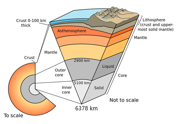
(1) Which are the three layers in the internal structure of the earth?
(2) From how many kilometres to how many kilometres is the depth of the earth's core?
(3) Which part of the earth is the source of magma of volcanic eruption?
Time 3 Hrs.
MM 70
General Instructions:
i. There are 30 questions in all. All questions are compulsory.
ii. Use of template or stencils for drawing outline maps is allowed.
SECTION – A (Q1 – 17)
(Multiple Choice Questions (MCQs) carrying 1 mark each) (Write only the correct answer in your answer sheets.)
(17 X 1 = 17)
Q 1 Which of the following scholars used the word Geography?
(a) Herodotus (b) Galileo (c) Eratosthenes (d) Aristotle
Q 2 Which of the following elements is not helpful in the formation and modification of the present atmosphere?
(a) Solar wind (b) Degassing (c) Differentiation (d) Photosynthesis
Q 3 Which of the following subjects does periodic synthesis?
(a) Sociology (b) Anthropology (c) History (d) Geography
Q 4 Which of the following is a direct means of information about interior of the earth?
(a) Seismic waves (b) Gravity (c) Volcano (d) Earth's magnetism
Q 5 About how many years ago did life on Earth begin?
(a) 1 billion 370 million years ago (b) 400 million years ago (c) 38 million years ago (d) 3 billion 800 million years ago
Q 6 Which of the following describes the lithosphere?
(a) upper and lower mantle (b) crust and core
(c) crust and upper mantle (d) mantle and core
Q 7 Deccan trap rock formations are the result of which type of volcanic eruption?
(a) Shield (b) Composite (c) flood (d) Caldera
Q 8 Which earthquake waves cause contraction and expansion in rocks:
(a) P waves (b) S waves (c) Surface waves (d) All
Q 9 If we travel from Rajasthan to Nagaland, which of the following rivers will not come on the way?
(a) Yamuna (b) Indus (c) Brahmaputra (d) Ganga
Q 10 With which of the following countries India has the longest terrestrial border?
(a) Bangladesh (b) Pakistan (c) China (d) Myanmar
Q 11 Which of the following country is larger than India in area?
(a) China (b) France (c) Egypt (d) Iran
Q 12 In which hill range is Dodabeta peak located?
(a) Nilgiri (b) Cardamom Hills (c) Anamalai (d) Nallamala
Q 13 Which water area separates Andaman and Nicobar?
(a) 11 degree channel (b) 10 degree channel
(c) Gulf of Mannar (d) Andaman Sea
Q 14 Which of the following river flows through the rift valley?
(a) Son (b) Yamuna (c) Narmada (d) Luni
Q 15 Which of the following is the confluence of Alaknanda and Bhagirathi?
(a) Vishnu Prayag (b) Rudra Prayag
(c) Karna Prayag (d) Dev Prayag
Q 16 What causes rainfall in the coastal areas of Tamil Nadu in early winter?
(a) South-west monsoon (b) North-east monsoon (c) Temperate cyclone (d) Local air circulation
Q 17 Which of the following river was known as 'Sorrow of Bengal'? (a) Gandak (b) Kosi (c) Son (d) Damodar
SECTION – B (Q18 - 23, Q19 & 19 are source based) (Short Answer Question carrying 3 Mark each) (Answer to each of these questions should not exceed 80-100 words.) (6 X 3 = 18)
Q 18 Look at the given picture and answer the following questions:-
(1) Which are the three layers in the internal structure of the earth?
(2) From how many kilometres to how many kilometres is the depth of the earth's core?
(3) Which part of the earth is the source of magma of volcanic eruption?
Q 19 Look at the given map and answer the following questions:-

(a) In which continent is India located?
(b) Which is the ocean located to the south of India?
(c) Which is the main centre of airways and sea routes in the east of India?
Q 20 Should we celebrate Van Mahotsav. If yes why?
Q 21 What was the form of the earth's surface in the initial period?
Q 22 What are the effects of India's long coastline? OR Write three characteristics of peninsular rivers.
Q 23 What is Inter Tropical Convergence Zone? OR What do you mean by social forestry?
SECTION – C (Q24 - 28) (Long Answer Question carrying 5 Mark each) (Answer to each of these questions should not exceed 150 words.) (5 X 5 = 25)
Q 24 What is Geography? What geographical and cultural facts do you look for while going to school? Why should they be included in the study of geography?
Q 25 What effect does the transmission of seismic waves have on the rocks through which they pass?
Q 26 Describe the Big Bang theory in detail. OR Briefly describe each stage while describing the developmental stages of the Earth.
Q 27 If you walk along the river Ganga from Badrinath to Sundarban delta, then describe with pictures what are the main landforms you will come across on your way. OR if you travel from Haridwar to Siliguri, then list down the rivers that will come on your route in an orderly manner and describe the characteristics of any one river.
Q 28 Describe the regional variations found in the climate of India with examples. OR What steps have been taken for forest conservation? How important is people's participation in these?
Map Work (Q29 & 30) (Identification or labeling of geographical features on Outline map of India and World, carrying 5 marks each. Maps provided to you must be attached within your answer book.) (5 X 2 = 10)
Map Work (Q29 & 30) (Identification or labeling of geographical features on Outline map of India and World, carrying 5 marks each. Maps provided to you must be attached within your answer book.) (5 X 2 = 10)
Q 29 Mark and state the following features on the political map of India. (any five)
(a) The southernmost point of the mainland of India
(b) Karakoram Range
(c) Nanda Devi mountain peak
(d) Narmada River
(e) A region with highest rainfall
(f) An area of deltaic forests
(g) Simlipal National Park

India Map for Q 29
Q 30 Identify any five features shown on the given outline map of the world and write their names in the blank spaces marked as A, B, C, D, E, F and G.
A. Second largest continent of the world
B.The world's largest ocean
C. An S shaped ocean
D. An ocean located to the south of India
E. Ocean near the North Pole
F. Smallest continent G. The third largest continent of the world

World Map for Q 30
👉CLICK HERE Below for
Class 11th Geography Half Yearly Paper 2023 (Hindi Medium)
(a) The southernmost point of the mainland of India
(b) Karakoram Range
(c) Nanda Devi mountain peak
(d) Narmada River
(e) A region with highest rainfall
(f) An area of deltaic forests
(g) Simlipal National Park
India Map for Q 29
Q 30 Identify any five features shown on the given outline map of the world and write their names in the blank spaces marked as A, B, C, D, E, F and G.
A. Second largest continent of the world
B.The world's largest ocean
C. An S shaped ocean
D. An ocean located to the south of India
E. Ocean near the North Pole
F. Smallest continent G. The third largest continent of the world
World Map for Q 30
👉CLICK HERE Below for
Class 11th Geography Half Yearly Paper 2023 (Hindi Medium)
Search Me On Google Using Keywords: -
#Abhimanyusir
#AbhimanyuDahiya
#UltimateGeography
Abhimanyu Sir
Visit My YouTube Channel Using Keywords: -
Abhimanyu Dahiya
Ultimate Geography