Chapter 7 Transport and Communication - Important Questions अध्याय 7 परिवहन एवं संचार - महत्वपूर्ण प्रश्न
Transport and
Communication: - We use many items in
our daily life. From toothpaste to our bed tea, milk, clothes, soaps, food
items, etc., are required every day. All these can be purchased from the
market.
All the production from the fields and factory, the produce is brought to the place from where consumers purchase it. It is the transportation of these items from the site of their production to the market which make them available to the consumer. We not only use material things, like fruits, vegetables, books, clothes, etc., but also use ideas, views and messages in our daily life. We exchange our views, ideas and messages from one place to another or one individual to another while communicating with the help of various means.
The use of transport and communication depends upon our need to move things from place of their availability to the place of their use. Human beings use various methods to move goods, commodities, ideas from one place to another.
परिवहन और संचार:- हम अपने दैनिक जीवन में कई वस्तुओं का उपयोग करते हैं। टूथपेस्ट से लेकर हमारी बिस्तर की चाय, दूध, कपड़े, साबुन, खाद्य पदार्थ आदि की हर दिन आवश्यकता होती है। ये सभी बाजार से खरीदे जा सकते हैं।
खेतों और कारखानों से सारा उत्पादन, उपज उस स्थान पर लाया जाता है जहाँ से उपभोक्ता इसे खरीदते हैं। इन वस्तुओं को उनके उत्पादन स्थल से बाजार तक पहुँचाने के लिए ही उन्हें उपभोक्ता तक पहुँचाया जाता है। हम न केवल भौतिक वस्तुओं जैसे फल, सब्ज़ियाँ, किताबें, कपड़े आदि का उपयोग करते हैं, बल्कि अपने दैनिक जीवन में विचारों, दृष्टिकोणों और संदेशों का भी उपयोग करते हैं। हम विभिन्न माध्यमों की सहायता से संचार करते हुए एक स्थान से दूसरे स्थान या एक व्यक्ति से दूसरे व्यक्ति तक अपने विचारों, विचारों और संदेशों का आदान-प्रदान करते हैं।
परिवहन
और संचार का उपयोग वस्तुओं को उनकी उपलब्धता के स्थान से उनके उपयोग के स्थान तक
ले जाने की हमारी आवश्यकता पर निर्भर करता है। मनुष्य वस्तुओं, वस्तुओं, विचारों
को एक स्थान से दूसरे स्थान तक ले जाने के लिए विभिन्न तरीकों का उपयोग करता है।
The following diagram shows the major means of transportation. निम्नलिखित चित्र परिवहन के प्रमुख साधनों को
दर्शाता है: -

Land Transport:-
The pathways and unmetalled roads have been used for
transportation in India since ancient times. With the economic and
technological development, metalled roads and railways were developed to move
large volume of goods and people from one place to another. Ropeways,
cableways and pipelines were devised to cater to the demands of
transporting specific goods under special circumstances.
स्थल
परिवहन:-
भारत में प्राचीन काल से ही परिवहन के लिए पक्की
सड़कों और कच्ची सड़कों का प्रयोग किया जाता रहा है। आर्थिक और तकनीकी विकास के
साथ, बड़ी
मात्रा में माल और लोगों को एक स्थान से दूसरे स्थान तक ले जाने के लिए पक्की
सड़कें और रेलवे विकसित किए गए। विशेष परिस्थितियों में विशिष्ट वस्तुओं के परिवहन
की मांग को पूरा करने के लिए रोपवे, केबलवे और पाइपलाइनों का
आविष्कार किया गया।
Road Transport
(i)
India has one of
the second largest road networks in the world with a total length of about 62.16 lakh km (morth.nic.in, Annual Report 2020-21).
(ii)
About
85 per cent of passenger and 70 per cent of freight traffic are carried by
roads every year.
(iii)
Road
transport is relatively suitable for shorter distance travel.
(iv)
Sher
Shah Suri built the Shahi (Royal) road to strengthen and consolidate
his empire from the Indus Valley
to the Sonar Valley in Bengal. This road was renamed the Grand Trunk (GT)
road during the British period, connecting Calcutta and Peshawar. At
present, it extends from Amritsar to Kolkata. It is bifurcated into 2 segments:
(a) National Highway (NH -1) from Delhi to Amritsar, and (b) NH-
2 from Delhi to Kolkata.
(v)
Road
transport in modern sense was very limited in India before World War-II.
(vi)
The
first serious attempt was made in 1943 when
‘Nagpur Plan’ was drawn. This plan could not be implemented due to lack of
coordination among the princely states and British India.
(vii)
After Independence, twenty-year road plan (1961) was introduced to improve the
conditions of roads in India.
(viii) However, roads continue to concentrate in and
around urban centres. Rural and remote areas had the least connectivity by
road.
सड़क परिवहन
(i) भारत की सड़कें दुनिया के दूसरे
सबसे बड़े सड़क नेटवर्क में से एक है, जिसकी कुल लंबाई लगभग
62.16 लाख किलोमीटर है (morth.nic.in,
वार्षिक रिपोर्ट 2020-21)।
(ii) हर साल लगभग 85 प्रतिशत
यात्री और 70 प्रतिशत माल यातायात, सड़कों द्वारा किया जाता है।
(iii) सड़क परिवहन कम दूरी की
यात्रा के लिए अपेक्षाकृत उपयुक्त है।
(iv) शेरशाह सूरी ने सिंधु घाटी से
बंगाल में सोनार घाटी तक अपने साम्राज्य को मजबूत और समेकित करने के लिए शाही
(रॉयल) सड़क का निर्माण किया। ब्रिटिश काल के दौरान इस सड़क का नाम बदलकर ग्रैंड
ट्रंक (GT) रोड कर दिया गया, जो
कलकत्ता और पेशावर को जोड़ती थी। वर्तमान में, यह अमृतसर से
कोलकाता तक फैली हुई है। इसे 2 खंडों में विभाजित किया गया है: (a) दिल्ली से अमृतसर तक राष्ट्रीय राजमार्ग (NH-1),
और (b) दिल्ली से कोलकाता तक NH-2.
(v) द्वितीय विश्व युद्ध से पहले
भारत में आधुनिक अर्थों में सड़क परिवहन बहुत सीमित था।
(vi) पहला गंभीर प्रयास 1943 में किया गया जब ‘नागपुर योजना’ तैयार की गई। रियासतों और
ब्रिटिश भारत के बीच समन्वय की कमी के कारण यह योजना लागू नहीं हो सकी।
(vii) स्वतंत्रता के बाद, भारत में सड़कों की स्थिति सुधारने के लिए बीस वर्षीय सड़क योजना
(1961) शुरू की गई।
(viii) हालाँकि, सड़कें शहरी क्षेत्रों में और उसके आसपास केंद्रित हैं। ग्रामीण और
दूरदराज के इलाकों में सड़क से संपर्क सबसे कम था।
For the purpose of construction and maintenance, roads are classified as National Highways (NH), State Highways (SH),
Major District Roads and Rural Roads.
निर्माण और रखरखाव के उद्देश्य से सड़कों को
राष्ट्रीय राजमार्ग (एनएच), राज्य राजमार्ग (एसएच), प्रमुख
जिला सड़कें और ग्रामीण सड़कें के रूप में वर्गीकृत किया जाता है।
National Highways
(i)
The main roads
which are constructed and maintained by the Central Government are known as
the National Highways.
(ii)
These
roads are meant for inter-state transport and movement of defence men and
material in strategic areas.
(iii)
These also connect
the state capitals, major cities, important ports, railway junctions, etc.
(iv)
The length of the
National Highways has increased from 19,700 km in 1951 to 1,36,440 km in 2020.
(v)
The National
Highways constitute only about 2 per cent of the total road length but carry 40
per cent of the road traffic.
(vi)
The
National Highways
Authority of India (NHAI)
was operationalized
in 1995. It is an autonomous body under the Ministry of Surface Transport. It is entrusted with the responsibility of
development, maintenance and operation of National Highways. This is also
the apex body (शीर्ष निकाय) to improve the quality of
the roads designated as National Highways.

राष्ट्रीय राजमार्ग
(i) मुख्य सड़कें जिनका निर्माण और
रखरखाव केंद्र सरकार द्वारा किया जाता है, उन्हें राष्ट्रीय
राजमार्ग के रूप में जाना जाता है।
(ii) ये सड़कें अंतर-राज्यीय
परिवहन और रणनीतिक क्षेत्रों में रक्षा कर्मियों और सामग्री की आवाजाही के लिए
हैं।
(iii) ये राज्य की राजधानियों,
प्रमुख शहरों, महत्वपूर्ण बंदरगाहों, रेलवे जंक्शनों आदि को भी जोड़ती हैं।
(iv) राष्ट्रीय राजमार्गों की
लंबाई 1951 में 19,700 किमी से बढ़कर 2020 में 1,36,440 किमी हो गई है।
(v) राष्ट्रीय राजमार्ग कुल
सड़क लंबाई का केवल लगभग 2 प्रतिशत हिस्सा बनाते हैं, लेकिन
सड़क यातायात का 40 प्रतिशत हिस्सा वहन करते हैं।
(vi) भारतीय राष्ट्रीय राजमार्ग
प्राधिकरण (NHAI) का संचालन 1995 में किया गया था। यह भूतल परिवहन मंत्रालय के तहत एक स्वायत्त निकाय है। इसे
राष्ट्रीय राजमार्गों के विकास, रखरखाव और संचालन की
जिम्मेदारी सौंपी गई है। यह राष्ट्रीय राजमार्गों के रूप में नामित सड़कों की
गुणवत्ता में सुधार करने के लिए सर्वोच्च निकाय (शीर्ष निकाय) भी है।
National Highways Development Projects (राष्ट्रीय राजमार्ग विकास परियोजनाएं)
NHAI has taken up some major projects in the
country under different phases: एनएचएआई ने देश में विभिन्न चरणों
में कुछ प्रमुख परियोजनाएं शुरू की हैं:
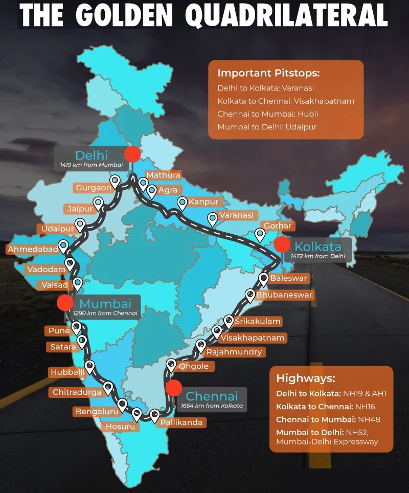
Golden Quadrilateral: It comprises construction
of 5,846 km long 4/6 lane, high density traffic corridor, to connect India’s
four big metro cities of Delhi-Mumbai-Chennai-Kolkata. With the
construction of Golden Quadrilateral, the time, distance and cost of movement
among the mega cities of India will be considerably minimised.
स्वर्णिम चतुर्भुज: इसमें भारत के चार बड़े महानगरों दिल्ली-मुंबई-चेन्नई-कोलकाता
को जोड़ने के लिए 5,846
किलोमीटर लंबे 4/6 लेन, उच्च घनत्व वाले यातायात गलियारे का
निर्माण शामिल है। स्वर्णिम चतुर्भुज के निर्माण से भारत के बड़े शहरों के बीच आवागमन
का समय, दूरी
और लागत काफी कम हो जाएगी।
North-South and East-West Corridors:
(a) North-South corridor aims at connecting Srinagar in
Jammu and Kashmir with Kanniyakumari in Tamil Nadu with 4,076-km
long road.
(b) The East-West Corridor has been planned to connect Silchar
in Assam with the port town of Porbandar in Gujarat with 3,640-km of
road length.
उत्तर-दक्षिण और
पूर्व-पश्चिम कॉरिडोर:
(ए) उत्तर-दक्षिण
कॉरिडोर का उद्देश्य जम्मू और कश्मीर में श्रीनगर को तमिलनाडु में कन्याकुमारी
से 4,076 किलोमीटर लंबी सड़क से जोड़ना है।
(बी) पूर्व-पश्चिम
कॉरिडोर की योजना असम में सिलचर को गुजरात के बंदरगाह शहर पोरबंदर से 3,640 किलोमीटर लंबी सड़क से
जोड़ने के लिए बनाई गई है।

State Highways
(i)
These are constructed
and maintained by state governments.
(ii)
They join the state
capitals with district headquarters and other important towns.
(iii)
These roads are
connected to the National Highways.
(iv)
These constitute 4
per cent of total road length in the country.
राज्य राजमार्ग
(i) इनका निर्माण और रखरखाव
राज्य सरकारों द्वारा किया जाता है।
(ii) ये राज्य की राजधानियों को
जिला मुख्यालयों और अन्य महत्वपूर्ण शहरों से जोड़ते हैं।
(iii) ये सड़कें राष्ट्रीय
राजमार्गों से जुड़ी होती हैं।
(iv) ये देश में कुल सड़क लंबाई
का 4 प्रतिशत हैं।
District Roads
(i)
These roads are the
connecting link between District Headquarters and the other important nodes in
the district.
(ii)
They account for 14
per cent of the total road length of the country.
जिला सड़कें
(i) ये सड़कें जिला
मुख्यालय और जिले के अन्य महत्वपूर्ण नोड्स के बीच संपर्क कड़ी हैं।
(ii) ये देश की कुल सड़क
लंबाई का 14 प्रतिशत हिस्सा हैं।
Rural Roads
(i)
These roads are vital
for providing links in the rural areas.
(ii)
About 80 per cent
of the total road length in India are categorised as rural roads.
(iii)
There is regional
variation in the density of rural road because these are influenced by the
nature of the terrain.
ग्रामीण सड़कें
(i) ये सड़के ग्रामीण
क्षेत्रों में संपर्क प्रदान करने के लिए महत्वपूर्ण हैं।
(ii) भारत में कुल सड़क
लंबाई का लगभग 80 प्रतिशत ग्रामीण सड़कों के रूप में वर्गीकृत है।
(iii) ग्रामीण सड़कों के
घनत्व में क्षेत्रीय भिन्नता है क्योंकि ये इलाके की प्रकृति से प्रभावित होती
हैं।

Why are the rural roads’ density very low in
hilly, plateau and forested areas? Why does the quality of rural roads
deteriorate away from the urban centres? पहाड़ी, पठारी और जंगली इलाकों में ग्रामीण सड़कों का घनत्व बहुत कम क्यों है?
शहरी केंद्रों से दूर ग्रामीण सड़कों की गुणवत्ता क्यों खराब हो
जाती है?
Other Roads - Other roads include Border Roads and International
Highways.
(i)
The Border Road Organisation (BRO) was established in May 1960 for accelerating
economic development and strengthening defence preparedness through rapid and
coordinated improvement of strategically important roads along the northern and
north-eastern boundary of the country.
(ii)
It is a premier
multifaceted construction agency.
(iii)
It
has constructed roads in high altitude mountainous terrain joining Chandigarh with Manali
(Himachal Pradesh) and Leh (Ladakh). This road runs at an
average altitude of 4,270 metres above the mean sea level.

(iv)
Apart
from the construction and maintenance of roads in strategically sensitive
areas, the BRO also undertakes snow clearance in high altitude areas.
(v)
The international
highways are meant to promote the harmonious relationship with the neighbouring
countries by providing effective links with India. (Fig. 7.4 and 7.5)

अन्य सड़कें - अन्य सड़कों में सीमा सड़कें और अंतर्राष्ट्रीय
राजमार्ग शामिल हैं।
(i) सीमा सड़क संगठन (बीआरओ) की स्थापना मई 1960 में देश की उत्तरी और उत्तर-पूर्वी सीमा पर रणनीतिक रूप से महत्वपूर्ण
सड़कों के तेजी से और समन्वित सुधार के माध्यम से आर्थिक विकास में तेजी लाने और
रक्षा तैयारियों को मजबूत करने के लिए की गई थी।
(ii) यह एक प्रमुख बहुमुखी निर्माण एजेंसी है।
(iii) इसने चंडीगढ़ को मनाली (हिमाचल प्रदेश) और लेह
(लद्दाख) से जोड़ने वाले उच्च ऊंचाई वाले पहाड़ी इलाकों में सड़कों का निर्माण
किया है। यह सड़क औसत समुद्र तल से 4,270 मीटर की औसत ऊंचाई
पर चलती है।
(iv) रणनीतिक रूप से संवेदनशील क्षेत्रों में सड़कों
के निर्माण और रखरखाव के अलावा, बीआरओ ऊंचाई वाले क्षेत्रों
में बर्फ हटाने का काम भी करता है।
(v) अंतर्राष्ट्रीय राजमार्गों का उद्देश्य भारत के
साथ प्रभावी संपर्क प्रदान करके पड़ोसी देशों के साथ सौहार्दपूर्ण संबंधों को
बढ़ावा देना है। (चित्र 7.4 और 7.5)
Why have Bengaluru and Hyderabad in the South and
Delhi, Kanpur and Patna in north India have emerged as important nodes?
दक्षिण भारत में बेंगलुरु और हैदराबाद तथा उत्तर
भारत में दिल्ली, कानपुर और
पटना महत्वपूर्ण केन्द्र बनकर क्यों उभरे हैं?
Do You Know?
The World’s longest Highway tunnel — Atal Tunnel (9.02 Km) has been built by
Border Road Organisation. This tunnel connects Manali to Lahaul-Spiti
valley throughout the year. Earlier the valley was cut off for about 6 months
each year owing to heavy snowfall. The Tunnel is built with ultra-modern
specifications in the Pir Panjal range of Himalayas at an altitude of
3000 metres from the Mean Sea Level (MSL).
दुनिया की सबसे लंबी राजमार्ग सुरंग - अटल
सुरंग (9.02 किलोमीटर) का निर्माण सीमा सड़क संगठन द्वारा किया गया है। यह
सुरंग पूरे साल मनाली को लाहौल-स्पीति घाटी से जोड़ती है। इससे पहले घाटी भारी
बर्फबारी के कारण हर साल लगभग 6 महीने तक कटी रहती थी। यह सुरंग हिमालय की पीर
पंजाल श्रृंखला में औसत समुद्र तल (MSL) से 3000 मीटर की ऊँचाई पर अत्याधुनिक
विशिष्टताओं के साथ बनाई गई है।
Source: https://www.marvels.bro.gov.in/AtalTunnel/About
Do You Know?
Bharatmala is a proposed umbrella scheme for:
(i) Development of State roads along coastal border areas,
including connectivity of non-major ports;
(ii) Backward areas religious and tourist places connectivity
programme;
(iii) Setubharatam Pariyojana, which is for the
consruction of about 1500 major bridges and 200 Railway over bridges rail
under bridges; District Headquarters connectivity Scheme for the development of
about 9000 km newly declared National Highways.
The programme is targeted for completion by 2022. Source:
Economic Survey 2015-16 pp.146.
भारतमाला निम्नलिखित के लिए एक प्रस्तावित
अम्ब्रेला योजना है:
(i) तटीय सीमा क्षेत्रों के साथ राज्य सड़कों का
विकास, जिसमें गैर-प्रमुख बंदरगाहों की कनेक्टिविटी शामिल है;
(ii) पिछड़े क्षेत्रों के धार्मिक और पर्यटन स्थलों
की कनेक्टिविटी कार्यक्रम;
(iii) सेतुभारतम परियोजना, जो
लगभग 1500 प्रमुख पुलों और 200 रेलवे ओवर ब्रिज और रेल अंडर ब्रिज के निर्माण के
लिए है; लगभग 9000 किलोमीटर नव घोषित राष्ट्रीय राजमार्गों
के विकास के लिए जिला मुख्यालय कनेक्टिविटी योजना।
कार्यक्रम को 2022 तक पूरा करने का लक्ष्य रखा
गया है। स्रोत: आर्थिक सर्वेक्षण 2015-16 पृष्ठ 146।
Rail Transport
(i)
Indian Railways, network
is one of the longest in the world.
(ii)
It facilitates the
movement of both freight and passengers and contributes to the growth of
the economy.
(iii)
Mahatma
Gandhi said, the Indian
railways “...brought people of diverse cultures together to contribute to
India’s freedom struggle”.
(iv)
Indian
Railway was introduced in 1853, when a line was constructed from Bombay to Thane covering a
distance of 34 km.
(v)
Indian Railways is the
largest government undertaking in the country.
(vi)
The length of Indian
Railways network was 67,956 km (Railway yearbook 2019-20). Its very large size
puts a lot of pressure on a centralised railway management system. Thus, in
India, the railway system has been divided into 16 zones.
रेल परिवहन
(i) भारतीय रेलवे, नेटवर्क दुनिया में सबसे लंबे नेटवर्क में से एक है।
(ii) यह माल और यात्रियों दोनों की
आवाजाही को सुगम बनाता है और अर्थव्यवस्था के विकास में योगदान देता है।
(iii) महात्मा गांधी ने कहा,
भारतीय रेलवे "...भारत के स्वतंत्रता संग्राम में योगदान देने
के लिए विभिन्न संस्कृतियों के लोगों को एक साथ लाया"।
(iv) भारतीय रेलवे की शुरुआत
1853 में हुई थी, जब बॉम्बे से थाने तक 34 किलोमीटर की
दूरी तय करने वाली एक लाइन का निर्माण किया गया था।
(v) भारतीय रेलवे देश का सबसे
बड़ा सरकारी उपक्रम है।
(vi) भारतीय रेलवे नेटवर्क की
लंबाई 67,956 किलोमीटर (रेलवे वर्ष
पुस्तिका 2019-20) थी। इसका बहुत बड़ा आकार एक केंद्रीकृत रेलवे प्रबंधन प्रणाली
पर बहुत दबाव डालता है। इस प्रकार, भारत में, रेलवे प्रणाली को 17 क्षेत्रों में विभाजित किया गया है।

Do You Know?
On the basis of the width
of track of the Indian Railways, three categories have been made:
Broad gauge: The distance between rails in broad gauge is 1.676 metre.
The total length of broad gauge lines was 63950 km (2019-20).
Metre gauge: The distance between rails is one metre. Its total length
was 2402 km (2019-20).
Narrow gauge: The distance between the rails in this
case is 0.762 metre or 0.610 metre. The total length of narrow guage was 1604
km (2019-20). It is generally confined to hilly areas.
भारतीय रेलवे की पटरियों की चौड़ाई के आधार पर
तीन श्रेणियां बनाई गई हैं:
ब्रॉड गेज: ब्रॉड गेज में पटरियों के बीच की दूरी 1.676
मीटर होती है। ब्रॉड गेज लाइनों की कुल लंबाई 63950 किमी (2019-20) थी।
मीटर गेज: पटरियों के बीच की दूरी एक मीटर होती है। इसकी
कुल लंबाई 2402 किमी (2019-20) थी।
नैरो गेज: इस मामले में पटरियों के बीच की दूरी 0.762
मीटर या 0.610 मीटर होती है। नैरो गेज की कुल लंबाई 1604 किमी (2019-20) थी। यह
आमतौर पर पहाड़ी इलाकों तक ही सीमित है।
You can watch - What is a
railway gauge? रेल गेज क्या होता है?
Indian Railways has launched extensive
programme to convert the metre and narrow gauges to broad gauge. Moreover, steam engines have been replaced
by diesel and electric engines. This step has increased the speed, as well
as, the haulage capacity (ढुलाई क्षमता).
The replacement of steam engines run by coal has also improved
the environment of the stations. Likely Kamlapati Railway Station in Madhya
Pradesh and Sonipat Junction is under Upgradation during this time.
Metro rail has revolutionlised the urban
transport system in Kolkata and Delhi.
भारतीय रेलवे ने मीटर और नैरो गेज को ब्रॉड गेज
में बदलने के लिए व्यापक कार्यक्रम शुरू किया है। इसके अलावा, भाप इंजन की जगह डीजल और
इलेक्ट्रिक इंजन ने ले ली है। इस कदम से गति के साथ-साथ ढुलाई क्षमता भी बढ़ी है।
कोयले से चलने वाले भाप इंजन की जगह पर स्टेशनों
के पर्यावरण में भी सुधार हुआ है। संभवतः मध्य प्रदेश में कमलापति रेलवे स्टेशन और
सोनीपत जंक्शन इस समय अपग्रेडेशन के अधीन हैं।
मेट्रो रेल ने कोलकाता और दिल्ली में शहरी
परिवहन प्रणाली में क्रांति ला दी है।
Which cities of India have Metro Rail Facility?
Collect information about it and discuss in the classroom. भारत
के किन शहरों में मेट्रो रेल सुविधा है? इसके बारे में
जानकारी एकत्र करें और कक्षा में चर्चा करें।
Note: - 15 Indian cities have an active metro rail service and an
operational metro map this time. The cities included in the metro route map of
India are Kolkata, Delhi, Chennai, Bengaluru, Hyderabad, Ahmedabad, Jaipur,
Gurugram, Mumbai, Noida, Kochi, Lucknow, Nagpur, Kanpur and Pune.
नोट: - इस समय 15 भारतीय शहरों में सक्रिय मेट्रो रेल सेवा और
परिचालन मेट्रो मानचित्र है। भारत के मेट्रो मार्ग मानचित्र में शामिल शहर हैं
कोलकाता, दिल्ली,
चेन्नई, बेंगलुरु, हैदराबाद,
अहमदाबाद, जयपुर, गुरुग्राम,
मुंबई, नोएडा, कोच्चि,
लखनऊ, नागपुर, कानपुर और
पुणे।
On March 6th 2024 PM of India inaugurated the
country's first under-river metro tunnel in the city of Kolkata in the
state of West Bengal. The metro tunnel has been built under the Hooghly
River, which connects the cities of Kolkata and Howrah.
6 मार्च 2024 को भारत के प्रधानमंत्री ने पश्चिम
बंगाल राज्य के कोलकाता शहर में देश की पहली अंडर-रिवर मेट्रो सुरंग का उद्घाटन
किया। मेट्रो सुरंग हुगली नदी के नीचे बनाई गई है, जो कोलकाता और हावड़ा शहरों को
जोड़ती है।
Replacement of diesel buses by CNG & Electricity-run vehicles along
with the introduction of metro is a welcome step towards controlling the
air pollution in urban centres.
डीजल बसों के स्थान पर सीएनजी और बिजली से चलने
वाले वाहनों को लाना तथा मेट्रो की शुरुआत करना शहरी केंद्रों में वायु प्रदूषण को
नियंत्रित करने की दिशा में एक स्वागत योग्य कदम है।
Areas around towns, raw material producing
areas and of plantations and other commercial crops, hill stations and
cantonment towns were well-connected by railways from the British colonial era. These were mostly developed for the exploitation of resources. After the Independence of the country, railway routes have been
extended to other areas too.
शहरों के आस-पास के इलाके, कच्चे माल के उत्पादन वाले
इलाके और बागानों और अन्य वाणिज्यिक फसलों के इलाके, हिल
स्टेशन और छावनी शहर ब्रिटिश औपनिवेशिक काल से ही रेलवे से अच्छी तरह जुड़े हुए
थे। इनका विकास ज़्यादातर संसाधनों के दोहन के लिए किया गया था। देश की आज़ादी के
बाद रेलवे रूट को दूसरे इलाकों तक भी बढ़ाया गया है।
Railway continues to remain the main means of transport for the masses. Railway network is relatively less dense in the
hill states, north eastern states, central parts of India and Rajasthan.
(Because of less population and urban centre in these areas due to relief,
hills and desert.)
रेलवे आज भी लोगों के लिए परिवहन का मुख्य साधन
बना हुआ है।
पहाड़ी राज्यों, पूर्वोत्तर
राज्यों, भारत के मध्य भागों और राजस्थान में रेलवे नेटवर्क
अपेक्षाकृत कम घना है। (क्योंकि इन क्षेत्रों में कम आबादी और शहरी केंद्र हैं,
जो पहाड़ी और रेगिस्तानी इलाकों के कारण हैं।)
Konkan Railway
One of the important achievements of the Indian Railways has
been the construction of Konkan Railway in 1998. It is 760-km long rail route connecting Roha in
Maharashtra to Mangalore in Karnataka. It is considered an engineering marvel. It crosses 146
rivers, streams, nearly 2000 bridges and 91 tunnels. Asia’s largest tunnel
which is nearly 6.5 km long, also lies on this route. The states of
Maharashtra, Goa and Karnataka arepartners in this undertaking.
कोंकण रेलवे
भारतीय रेलवे की महत्वपूर्ण उपलब्धियों में से
एक 1998 में
कोंकण रेलवे का निर्माण है। यह महाराष्ट्र के रोहा को कर्नाटक के मैंगलोर से जोड़ने
वाला 760 किलोमीटर
लंबा रेल मार्ग है। इसे इंजीनियरिंग का एक चमत्कार माना जाता है। यह 146 नदियों, नालों, लगभग 2000 पुलों और 91
सुरंगों को पार करता है। एशिया की सबसे बड़ी सुरंग जो लगभग 6.5
किलोमीटर लंबी है, भी इसी मार्ग पर स्थित है।
महाराष्ट्र, गोवा और कर्नाटक राज्य इस उपक्रम में भागीदार
हैं।
Water Transport
(i)
Waterways
is an important mode of transport for both passenger and cargo traffic in
India.
(ii)
It
is the cheapest means of transport and is most suitable for carrying
heavy and bulky material.
(iii)
It
is a fuel-efficient and eco-friendly mode of transport.
(iv)
The
water transport is of two types– (a) inland waterways, and (b) oceanic
waterways.
जल परिवहन
(i) जलमार्ग भारत में यात्री और
माल यातायात दोनों के लिए परिवहन का एक महत्वपूर्ण साधन है।
(ii) यह परिवहन का सबसे सस्ता
साधन है और भारी और भारी सामग्री को ले जाने के लिए सबसे उपयुक्त है।
(iii) यह परिवहन का एक ईंधन-कुशल
और पर्यावरण-अनुकूल तरीका है।
(iv) जल परिवहन दो प्रकार का होता
है- (a) अंतर्देशीय जलमार्ग, और (b)
समुद्री जलमार्ग।

Inland Waterways
(i)
It was the chief
mode of transport before the advent of railways.
(ii)
It, however, faced
tough competition from road and railway transport.
(iii)
Moreover, diversion
of river water for irrigation purposes made them non-navigable in large parts
of their courses.
(iv)
India
has 14,500 km of navigable waterways, contributing about 1% to the country’s transportation.
(v)
It comprises
rivers, canals, backwaters, creeks, etc.
(vi)
At present, 5,685 km
of major rivers are navigable by mechanised flat bottom vessels.
(vii)
For the development,
maintenance and regulation of national waterways in the country, the Inland
Waterways Authority was set up in 1986.
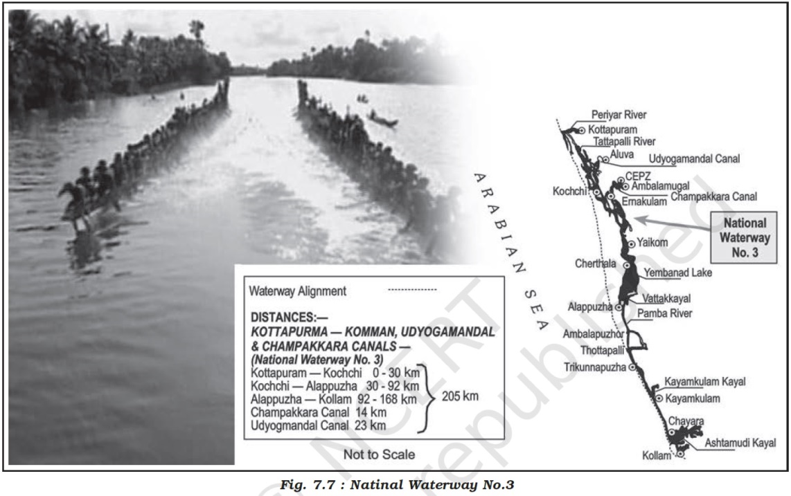
(viii) The following waterways have been declared as the
National Waterways by the Government (Table 7.3).

(ix)
The Inland Waterways
Authority has also identified 10 other inland waterways, which could be upgraded.
(x)
The backwaters (Kayal)
of Kerala has special significance in Inland Waterway. Apart from providing
cheap means of transport, they are also attracting a large number of tourists
in Kerala.
(xi)
The famous Nehru
Trophy Boat Race (VALLAMKALI) is also held in the backwaters.
अंतर्देशीय जलमार्ग
(i) रेलवे के आगमन से पहले यह परिवहन का मुख्य
साधन था।
(ii) हालाँकि, इसे सड़क और
रेलवे परिवहन से कड़ी प्रतिस्पर्धा का सामना करना पड़ा।
(iii) इसके अलावा, सिंचाई
के उद्देश्य से नदी के पानी को मोड़ने से उनके बड़े हिस्से में नौगम्यता समाप्त हो
गई।
(iv) भारत में 14,500
किलोमीटर नौगम्य जलमार्ग हैं, जो देश के परिवहन में लगभग 1% का योगदान करते हैं।
(v) इसमें नदियाँ, नहरें,
बैकवाटर, खाड़ियाँ आदि शामिल हैं।
(vi) वर्तमान में, 5,685
किलोमीटर प्रमुख नदियाँ मशीनीकृत सपाट तल वाले जहाजों द्वारा नौगम्य हैं।
(vii) देश में राष्ट्रीय जलमार्गों के विकास,
रखरखाव और विनियमन के लिए, 1986 में
अंतर्देशीय जलमार्ग प्राधिकरण की स्थापना की गई थी।
(viii) सरकार द्वारा निम्नलिखित जलमार्गों को
राष्ट्रीय जलमार्ग घोषित किया गया है (तालिका 7.3)।
(ix) अंतर्देशीय जलमार्ग प्राधिकरण ने 10 अन्य अंतर्देशीय जलमार्गों की भी पहचान की है, जिन्हें
उन्नत किया जा सकता है।
(x) अंतर्देशीय जलमार्ग में केरल के बैकवाटर
(कयाल) का विशेष महत्व है। परिवहन के सस्ते साधन उपलब्ध कराने के अलावा, वे केरल में बड़ी संख्या में पर्यटकों को भी आकर्षित कर रहे हैं।
(xi) प्रसिद्ध नेहरू ट्रॉफी बोट रेस (वल्लमकली)
भी बैकवाटर में आयोजित की जाती है।
Oceanic Routes
(i)
India has a vast
coastline of approximate 7,517 km, including islands.
(ii)
Twelve
major and 185 minor ports
provide infrastructural support to these routes.
(iii)
Oceanic
routes play an important role in the transport sector of India’s economy.
(iv)
Approximately 95
per cent of India’s foreign trade by volume and 70 per cent by value moves
through ocean routes.
(v)
Apart from
international trade, these are also used for the purpose of transportation
between the islands and the rest of the country.
समुद्री मार्ग
(i) भारत में द्वीपों सहित लगभग 7,517 किलोमीटर की विशाल तटरेखा है।
(ii) बारह प्रमुख और 185 छोटे
बंदरगाह इन मार्गों को बुनियादी ढाँचागत सहायता प्रदान करते हैं।
(iii) समुद्री मार्ग भारत की अर्थव्यवस्था के परिवहन
क्षेत्र में महत्वपूर्ण भूमिका निभाते हैं।
(iv) मात्रा के हिसाब से भारत का लगभग 95 प्रतिशत और मूल्य के हिसाब से 70 प्रतिशत विदेशी
व्यापार समुद्री मार्गों से होता है।
(v) अंतर्राष्ट्रीय व्यापार के अलावा, इनका उपयोग द्वीपों और देश के बाकी हिस्सों के बीच परिवहन के उद्देश्य से
भी किया जाता है।
Air Transportation
(i)
Air transport is the fastest means of movement from
one place to the other.
(ii)
It has reduced distances by minimising the travel
time.
(iii)
It is essential for
a vast country like India, where distances are large and the terrain and
climatic conditions are diverse.
(iv)
Air
transport in India made a beginning in 1911 when airmail operation commenced over a little distance of
10 km between Allahabad (Prayagraj) and Naini.
(v)
But its real
development took place in post-Independent period.
(vi)
The Airport Authority of India is responsible for providing safe,
efficient air traffic and aeronautical communication services in the Indian
Air Space.
Note - (AAI
was constituted by an Act
of Parliament and came into being on 1st April 1995 by merging
erstwhile National Airports Authority and International Airports
Authority of India. AAI
manages a total of 137 airports during the year 2019-20, which include 24
International airports (3 Civil Enclaves) (A civil enclave is an area at a
military airbase allotted for the usage of civil aviation. There are 26 civil
enclaves in Defence Airfields.), 10 Custom Airports (4 Civil Enclaves) and 103
Domestic airports (23 Civil Enclaves).)
(vii)
The authority manages more
than 125 airports (a total of 137 airports during the year
2019-20).
(viii) Pawan Hans is the helicopter service operating in hilly areas and is widely used
by tourists in north-eastern sector.
(ix)
In addition, Pawan
Hans Limited mainly provides helicopter services to petroleum sector and for
tourism.
वायु परिवहन
(i)
वायु परिवहन एक स्थान से दूसरे स्थान तक जाने का सबसे तेज़ साधन है।
(ii)
इसने यात्रा के समय को कम करके दूरियाँ कम कर दी हैं।
(iii)
यह भारत जैसे विशाल देश के लिए आवश्यक है, जहाँ
दूरियाँ बड़ी हैं और भूभाग और जलवायु परिस्थितियाँ विविध हैं।
(iv)
भारत में वायु परिवहन की शुरुआत 1911 में हुई
जब इलाहाबाद (प्रयागराज) और नैनी के बीच 10 किलोमीटर की छोटी
दूरी पर हवाई डाक सेवा शुरू हुई।
(v)
लेकिन इसका वास्तविक विकास स्वतंत्रता के बाद हुआ।
(vi)
भारतीय हवाई अड्डा प्राधिकरण भारतीय वायु क्षेत्र में सुरक्षित,
कुशल हवाई यातायात और वैमानिकी संचार सेवाएँ प्रदान करने के लिए
जिम्मेदार है।
नोट - (एएआई का गठन संसद के एक अधिनियम द्वारा किया गया था और 1 अप्रैल 1995 को तत्कालीन
राष्ट्रीय हवाईअड्डा प्राधिकरण और भारतीय अंतर्राष्ट्रीय हवाईअड्डा प्राधिकरण को
विलय करके अस्तित्व में आया था। एएआई वर्ष 2019-20 के दौरान
कुल 137 हवाईअड्डों का प्रबंधन करता है, जिसमें 24 अंतर्राष्ट्रीय हवाईअड्डे (3 सिविल एन्क्लेव) शामिल हैं (एक सिविल एन्क्लेव नागरिक उड्डयन के उपयोग के
लिए आवंटित सैन्य एयरबेस पर एक क्षेत्र है। रक्षा एयरफील्ड में 26 सिविल एन्क्लेव हैं।), 10 कस्टम हवाईअड्डे (4 सिविल एन्क्लेव) और 103 घरेलू हवाईअड्डे (23 सिविल एन्क्लेव)।)
(vii)
प्राधिकरण 125 से अधिक हवाईअड्डों (वर्ष 2019-20 के दौरान कुल 137 हवाईअड्डे) का प्रबंधन करता है।
(viii)
पवन हंस पहाड़ी क्षेत्रों में संचालित हेलीकॉप्टर सेवा है।
Oil and Gas Pipelines
(i)
Pipelines
are the most convenient and efficient mode of transporting liquids and gases
over long distances.
(ii)
Even solids can
also be transported by pipelines after converting them into slurry.
(iii)
Oil
India Limited (OIL) under the
administrative set up of the Ministry of Petroleum and Natural Gas is engaged
in the exploration, production and transportation of crude oil and natural gas.
(iv)
It was incorporated
in 1959 as a company.
(v)
Asia’s
first cross country pipeline covering a distance of 1,157 km was constructed
by oil from Naharkatiya oilfield in Assam to Barauni refinery in
Bihar. It was further
extended up to Kanpur in 1966.
(vi)
GAIL
(India) Ltd. was set up in 1984 as a public sector undertaking to transport process and market natural gas
for its economic use.
(vii)
The
first 1,700 km long Hazira-Vijaipur - Jagdishpur (HVJ) cross country gas
pipeline, constructed by GAIL (India), linked Mumbai High and Bassein gas fields with various
fertiliser, power and industrial complexes in western and northern India.
(viii) This artery provided impetus to Indian gas
market development.
(ix)
Overall, India’s
gas infrastructure has expanded over ten times from 1,700 km to 18,500 km of
cross-country pipelines and is expected to soon reach over 34,000 km as Gas
Grid by linking all the gas sources and consuming markets across the
country including North Eastern States.
तेल और गैस पाइपलाइनें
(i) पाइपलाइनें तरल पदार्थों और
गैसों को लंबी दूरी तक ले जाने का सबसे सुविधाजनक और कुशल तरीका है।
(ii) ठोस पदार्थों को भी घोल में
परिवर्तित करने के बाद पाइपलाइनों द्वारा ले जाया जा सकता है।
(iii) पेट्रोलियम और प्राकृतिक
गैस मंत्रालय के प्रशासनिक ढांचे के तहत ऑयल इंडिया लिमिटेड (OIL) कच्चे तेल और प्राकृतिक गैस की खोज, उत्पादन और
परिवहन में लगा हुआ है।
(iv) इसे 1959 में एक कंपनी के रूप में शामिल किया गया था।
(v) एशिया की पहली क्रॉस कंट्री
पाइपलाइन 1,157 किलोमीटर की दूरी तय करती है, जिसका निर्माण असम के नहरकटिया तेल क्षेत्र से बिहार के बरौनी रिफाइनरी तक
तेल द्वारा किया गया था। इसे 1966 में कानपुर तक आगे बढ़ाया
गया।
(vi) गेल (इंडिया) लिमिटेड की
स्थापना 1984 में एक सार्वजनिक क्षेत्र के उपक्रम के रूप में
की गई थी, जिसका उद्देश्य प्राकृतिक गैस के परिवहन, प्रसंस्करण और विपणन को आर्थिक उपयोग के लिए करना था।
(vii) गेल (इंडिया) द्वारा
निर्मित पहली 1,700 किलोमीटर लंबी हजीरा-विजयपुर-जगदीशपुर
(एचवीजे) क्रॉस कंट्री गैस पाइपलाइन ने मुंबई हाई और बेसिन गैस क्षेत्रों को
पश्चिमी और उत्तरी भारत में विभिन्न उर्वरक, बिजली और
औद्योगिक परिसरों से जोड़ा।
(viii) इस धमनी ने भारतीय गैस
बाजार के विकास को गति प्रदान की।
(ix) कुल मिलाकर, भारत का गैस बुनियादी ढांचा 1,700 किलोमीटर से दस
गुना बढ़कर 18,500 किलोमीटर क्रॉस-कंट्री पाइपलाइनों तक
पहुंच गया है और उम्मीद है कि जल्द ही पूर्वोत्तर राज्यों सहित देश भर में सभी गैस
स्रोतों और उपभोक्ता बाजारों को जोड़कर गैस ग्रिड के रूप में 34,000 किलोमीटर से अधिक तक पहुंच जाएगा।
Communication Networks
(i)
Human beings have
evolved different methods of communication over time.
(ii)
In earlier times, the
messages were delivered by beating the drum or hollow tree trunks, giving
indications through smoke or fire or with the help of fast runners.
(iii)
Horses, camels, dogs,
birds and other animals were also used to send messages.
(iv)
Initially,
the means of communication were also the means of transportation.
(v)
Invention of post-
office, telegraph (Note -
Telegraph was first installed in 1851 and a trans-India telegraph was completed
three years later in 1854. 163 year old telegram service to close forever at 9
pm on 14th July, 2013.), printing press,
telephone, satellite, etc has made the communication much faster and easier.
(vi)
Development in the
field of science and technology has significantly contributed in bringing about
revolution in the field of communication.
(vii)
People use different modes of communication to convey the messages. On the basis of scale and quality,
the mode of communication can be divided into following categories:

संचार नेटवर्क
(i)
समय के साथ मनुष्य ने संचार के विभिन्न तरीके विकसित किए हैं।
(ii)
पहले के समय में ढोल बजाकर या पेड़ के खोखले तने को पीटकर, धुएँ या आग के ज़रिए या तेज़ दौड़ने वालों की मदद से संदेश पहुँचाए जाते
थे।
(iii)
संदेश भेजने के लिए घोड़े, ऊँट, कुत्ते, पक्षी और दूसरे जानवरों का भी इस्तेमाल किया
जाता था।
(iv)
शुरू में संचार के साधन परिवहन के साधन भी थे।
(v)
डाकघर, टेलीग्राफ़ (नोट - टेलीग्राफ़ पहली बार
1851 में लगाया गया था और तीन साल बाद 1854 में ट्रांस-इंडिया टेलीग्राफ़ बनकर तैयार हुआ था। 163 साल पुरानी टेलीग्राम सेवा 14 जुलाई, 2013 को रात 9 बजे हमेशा के लिए बंद हो जाएगी।), प्रिंटिंग प्रेस, टेलीफोन, सैटेलाइट
आदि के आविष्कार ने संचार को बहुत तेज़ और आसान बना दिया है।
(vi)
विज्ञान और प्रौद्योगिकी के क्षेत्र में विकास ने संचार के क्षेत्र
में क्रांति लाने में महत्वपूर्ण योगदान दिया है।
(vii)
लोग संदेश पहुँचाने के लिए संचार के विभिन्न तरीकों का इस्तेमाल
करते हैं। पैमाने और गुणवत्ता के आधार पर संचार के तरीकों को निम्नलिखित श्रेणियों
में विभाजित किया जा सकता है:
Personal Communication System
(i)
Among all the personal
communication system internet is the most effective and advanced one.
(ii)
It is widely used
in urban areas.
(iii)
It enables the user
to establish direct contact through e-mail to get access to the world of
knowledge and information.
(iv)
It is increasingly
used for e-commerce and carrying out money transactions, likely UPI and Online
Banking.
(v)
The internet is
like a huge central warehouse of data, with detailed information on various
items.
(vi)
The network through
internet and e-mail provides an efficient access to information at a
comparatively low cost.
(vii)
It enables us with the
basic facilities of direct communication.
व्यक्तिगत संचार प्रणाली
(i)
सभी व्यक्तिगत संचार प्रणालियों में इंटरनेट सबसे प्रभावी और उन्नत
है।
(ii)
शहरी क्षेत्रों में इसका व्यापक रूप से उपयोग किया जाता है।
(iii)
यह उपयोगकर्ता को ज्ञान और सूचना की दुनिया तक पहुँच प्राप्त करने
के लिए ई-मेल के माध्यम से सीधा संपर्क स्थापित करने में सक्षम बनाता है।
(iv)
इसका उपयोग ई-कॉमर्स और पैसे के लेन-देन, संभवतः
यूपीआई और ऑनलाइन बैंकिंग के लिए तेजी से किया जा रहा है।
(v)
इंटरनेट डेटा के एक विशाल केंद्रीय गोदाम की तरह है, जिसमें विभिन्न वस्तुओं पर विस्तृत जानकारी होती है।
(vi)
इंटरनेट और ई-मेल के माध्यम से नेटवर्क तुलनात्मक रूप से कम लागत पर
सूचना तक कुशल पहुँच प्रदान करता है।
(vii)
यह हमें सीधे संचार की बुनियादी सुविधाएँ प्रदान करता है।
Mass Communication System जन
संचार प्रणाली
Radio
(i)
Radio
broadcasting started in India in 1923 by
the Radio Club of Bombay.
(ii)
Since then, it
gained immense popularity and changed the socio-cultural life of
people.
(iii)
Within no time, it
made a place in every household of the country.
(iv)
Government took this
opportunity and brought this popular mode of communication under its control in
1930 under the Indian Broadcasting System.
(v)
It
was changed to All India Radio in 1936 and to Akashwani in 1957.
(vi)
All
India Radio broadcasts a variety of programmes related to information, education and
entertainment.
(vii)
Special
news bulletins are also broadcast at specific occasions like session of parliament and state
legislatures.
रेडियो
(i) भारत में रेडियो प्रसारण की शुरुआत 1923 में बॉम्बे रेडियो क्लब द्वारा की गई थी।
(ii) तब से इसने बहुत लोकप्रियता हासिल की और लोगों
के सामाजिक-सांस्कृतिक जीवन को बदल दिया।
(iii) कुछ ही समय में इसने देश के हर घर में जगह बना
ली।
(iv) सरकार ने इस अवसर का लाभ उठाया और 1930 में भारतीय प्रसारण प्रणाली के तहत संचार के इस लोकप्रिय माध्यम को अपने
नियंत्रण में ले लिया।
(v) इसे 1936 में ऑल इंडिया
रेडियो और 1957 में आकाशवाणी में बदल दिया गया।
(vi) ऑल इंडिया रेडियो सूचना, शिक्षा
और मनोरंजन से संबंधित विभिन्न प्रकार के कार्यक्रम प्रसारित करता है।
(vii) संसद और राज्य विधानसभाओं के सत्र जैसे
विशिष्ट अवसरों पर विशेष समाचार बुलेटिन भी प्रसारित किए जाते हैं।
Television (T.V.)
(i)
Television
broadcasting has emerged as the most effective audio-visual medium for disseminating information and educating
masses.
(ii)
Initially, the T.V.
services were limited only to the National Capital where it began in
1959.
(iii)
After 1972, several
other centres became operational.
(iv)
In
1976, TV was delinked from All India Radio (AIR) and got a separate identity as Doordarshan (DD).
(v)
After INSAT-IA (National Television-DD1) became operational, Common National Programmes (CNP) were
started for the entire network and its services were extended to the backward
and remote rural areas.
टेलीविजन (टी.वी.)
(i) टेलीविजन प्रसारण सूचना प्रसारित करने और जनता
को शिक्षित करने के लिए सबसे प्रभावी दृश्य-श्रव्य माध्यम के रूप में उभरा है।
(ii) प्रारंभ में, टी.वी.
सेवाएँ केवल राष्ट्रीय राजधानी तक ही सीमित थीं, जहाँ 1959 में इसकी शुरुआत हुई थी।
(iii) 1972 के बाद, कई अन्य
केंद्र चालू हो गए।
(iv) 1976 में, टीवी को ऑल
इंडिया रेडियो (एआईआर) से अलग कर दिया गया और दूरदर्शन (डीडी) के रूप में एक अलग
पहचान मिली।
(v) इनसैट-आईए (राष्ट्रीय टेलीविजन-डीडी 1) चालू होने के बाद, पूरे नेटवर्क के लिए कॉमन नेशनल
प्रोग्राम (सीएनपी) शुरू किए गए और इसकी सेवाओं को पिछड़े और दूरदराज के ग्रामीण क्षेत्रों
तक बढ़ाया गया।
Satellite Communication
(i)
Satellites are mode of communication in themselves
as well as they regulate the use of other means of communication.
(ii)
However, use of
satellite in getting a continuous and synoptic view (संक्षिप्त
अवलोकन) of larger area has made satellite communication very vital
for the country due to the economic and strategic reasons.
(iii)
Satellite images can be used for the weather
forecast, monitoring of natural calamities, surveillance of border areas, etc.
(iv)
On
the basis of configuration and purposes, satellite system in India can be
grouped into two: Indian National Satellite System (INSAT) and Indian Remote Sensing Satellite System (IRS).
(v)
The
INSAT, which was established in 1983, is a multi-purpose satellite system for telecommunication,
meteorological observation and for various other data and programmes.
(vi)
The
IRS satellite system became operational with the launching of IRS-IA in March
1988 from Vaikanour in Russia.
(vii)
India has also
developed her own Launching Vehicle PSLV (Polar Satellite Launch Vehicle).
(viii) These satellites collect data in several
spectral bands and transmit them to the ground stations for various uses.
(ix)
The National Remote
Sensing Centre (NRSC) at Hyderabad provides facilities for acquisition of
data and its processing. (हैदराबाद स्थित राष्ट्रीय रिमोट सेंसिंग
सेंटर (एनआरएससी) डेटा के अधिग्रहण और उसके प्रसंस्करण के लिए सुविधाएं प्रदान
करता है।)
(x)
These are very useful
in the management of natural resources.
उपग्रह संचार
(i) उपग्रह स्वयं संचार का एक
माध्यम हैं और साथ ही वे संचार के अन्य साधनों के उपयोग को विनियमित करते हैं।
(ii) हालांकि, बड़े क्षेत्र का सतत और संक्षिप्त दृश्य (संक्षिप्त अवलोकन) प्राप्त करने
में उपग्रह के उपयोग ने आर्थिक और रणनीतिक कारणों से देश के लिए उपग्रह संचार को
बहुत महत्वपूर्ण बना दिया है।
(iii) उपग्रह चित्रों का उपयोग
मौसम पूर्वानुमान, प्राकृतिक आपदाओं की निगरानी, सीमावर्ती क्षेत्रों की निगरानी आदि के लिए किया जा सकता है।
(iv) विन्यास और उद्देश्यों के
आधार पर, भारत में उपग्रह प्रणाली को दो समूहों में बांटा जा
सकता है: भारतीय राष्ट्रीय उपग्रह प्रणाली (INSAT) और भारतीय
सुदूर संवेदन उपग्रह प्रणाली (IRS)।
(v) INSAT, जिसे 1983 में स्थापित किया गया था, दूरसंचार, मौसम संबंधी अवलोकन और विभिन्न अन्य डेटा और कार्यक्रमों के लिए एक
बहुउद्देश्यीय उपग्रह प्रणाली है।
(vi) IRS उपग्रह प्रणाली मार्च 1988 में रूस के वैकनौर से IRS-IA के प्रक्षेपण के साथ
चालू हो गई।
(vii) भारत ने अपना खुद का
लॉन्चिंग व्हीकल PSLV (पोलर सैटेलाइट लॉन्च व्हीकल) भी
विकसित किया है।
(viii) ये उपग्रह कई वर्णक्रमीय
बैंडों में डेटा एकत्र करते हैं और उन्हें विभिन्न उपयोगों के लिए ग्राउंड
स्टेशनों तक पहुंचाते हैं।
(ix) हैदराबाद स्थित राष्ट्रीय
रिमोट सेंसिंग सेंटर (एनआरएससी) डेटा के अधिग्रहण और उसके प्रसंस्करण के लिए
सुविधाएं प्रदान करता है। (हैदराबाद स्थित नेशनल इलेक्ट्रिकल सेंसिंग सेंटर
(नोट्स) डेटा के भंडार और अपनी कंपनी के लिए सेवाएं प्रदान करता है।)
(x) ये प्राकृतिक संसाधनों के
प्रबंधन में बहुत उपयोगी हैं।
EXERCISES
1. Choose the right answers of the following
from the given options.
(i) In how many zones has the Indian Railways
system been divided?
(a) 9 (c) 17
(b) 12 (d) 14
(ii) On which river and between which two
places does the National Water Way No. 1 lie?
(a) The Brahmaputra, Sadiya-Dhubri
(b) The Ganga, Haldia-Allahabad
(c) West Coast Canal, Kottapuram to Kollam
(iii) In which of the following year, the
first radio programme was broadcast?
(a) 1911 (c) 1927
(b) 1936 (d) 1923
दिए गए विकल्पों में से सही उत्तर चुनें।
(i) भारतीय रेलवे प्रणाली को कितने क्षेत्रों
में विभाजित किया गया है?
(a)
9 (c) 17
(b)
12 (d) 14
(ii) राष्ट्रीय जलमार्ग संख्या 1 किस नदी पर और किन दो स्थानों के बीच स्थित है?
(a)
ब्रह्मपुत्र, सदिया-धुबरी
(b)
गंगा, हल्दिया-इलाहाबाद
(c)
पश्चिमी तट नहर, कोट्टापुरम से कोल्लम
(iii) निम्नलिखित में से किस वर्ष पहला रेडियो
कार्यक्रम प्रसारित किया गया था?
(a)
1911 (c) 1927
(b)
1936 (d) 1923
2. Answer the following questions in about 30
words.
(i) Which activity does transportation convey? Name three major
modes of transportation.
(ii) Discuss advantages and disadvantages of pipeline
transportation.
(iii) What do you mean by ‘communication’?
(iv) Discuss the contribution of Air India and Indian in the air
transport of India.
निम्नलिखित प्रश्नों के उत्तर लगभग 30 शब्दों में दीजिए।
(i)
परिवहन किस गतिविधि को संप्रेषित करता है? परिवहन
के तीन प्रमुख साधनों के नाम बताइए।
(ii)
पाइपलाइन परिवहन के लाभ और हानि पर चर्चा कीजिए।
(iii)
'संचार' से आपका क्या अभिप्राय है?
(iv)
भारत के हवाई परिवहन में एयर इंडिया और इंडियन के योगदान पर चर्चा
कीजिए।
3. Answer the following questions in about
150 words.
(i) Which are the chief means of transportation in India?
Discuss the factors affecting their development.
(ii) Give a detailed account of the development of railways in
India and highlight their importance.
(iii) Describe the role of roads in the economic development of
India.
3. निम्नलिखित प्रश्नों के उत्तर लगभग 150 शब्दों में दीजिए।
(i) भारत में परिवहन के मुख्य साधन कौन-कौन से हैं?
उनके विकास को प्रभावित करने वाले कारकों पर चर्चा कीजिए।
(ii) भारत में रेलवे के विकास का विस्तृत विवरण
दीजिए तथा उनके महत्व पर प्रकाश डालिए।
(iii) भारत के आर्थिक विकास में सड़कों की भूमिका का
वर्णन कीजिए।
Project परियोजना
Find out the facilities that Indian Railways provide to the
passengers.
भारतीय रेलवे यात्रियों को कौन-सी सुविधाएँ प्रदान करती है, इसका पता लगाइए।
