1. The vegetation of savannah consists of grassland with scattered small trees. The forest development in such areas is generally kept in check by one or more or a combination of some conditions.
 |
| the vegetation of savannah grassland |
1. Burrowing animals and termites.
2. Fire
3. Grazing herbivores
4. Seasonal rainfall
5. Soil properties
Select the correct answer using the code given below.
(a) 1 and2
(b) 4 and 5
(c) 2, 3 and 4
(d) 1, 3 and 5
 |
| Savannah Grassland |
 |
Scattered trees and tall grasses savanna landscapes.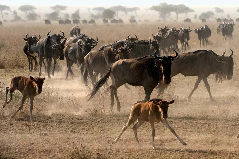 |
2. With reference to the water on the planet Earth, consider the following statements:
1. The amount of water in the rivers and lakes is more than the amount of groundwater.
2. The amount of water in polar ice caps and glaciers is more than the amount of groundwater.
 |
| Amount of water on the Earth |
(a) 1 only
(b) 2 only
(c) Both 1 and 2
(d) Neither 1 nor 2
3. Consider the following statements:
1. Moringa (drumstick tree) is a leguminous evergreen tree.
2. Tamarind tree is endemic to south Asia.
3. In India, most of the tamarind is collected as minor forest produce.
4. India exports tamarind and seeds of moringa.
5. Seeds of moringa and tamarind can be used in the production of biofuels.
Which of the statements given above are correct?
(a) 1, 2, 4 and 5
(b) 3, 4 and 5
(c) 1, 3 and 4
(d) 1,2, 3 and 5
Note - Characteristics of the Moringa (drumstick tree)? सहजन के पेड़ की विशेषताएं
 |
| Moringa |
 |
| Tamarind |
(a) Brown forest soil
(b) Fissure volcanic rock
(c) Granite and schist
(d) Shale and limestone
 |
| The black cotton soil. |
5. How is permaculture farming different from conventional chemical farming?
1. Permaculture farming discourages monocultural practices but in conventional chemical farming, monoculture practices are predominant.
2. Conventional chemical farming can cause increase in soil salinity but the occurrence of such phenomenon is not observed in permaculture farming.
3. Conventional chemical farming is easily possible in such regions.
4. Practice of mulching is very important in permaculture farming but not necessarily so in conventional chemical farming.
Select the correct answer using the code given below.
(a) 1 and 3
(b) 1, 2 and 4
(c) 4 only
(d) 2 and 3
 |
| Permaculture |
Conventional farming is the method of farming that involves using pesticides and other chemicals to get the highest possible yield of crops. However, using this method compromises on crop quality. The chemicals seep into the soil and enter the food chain at multiple points.
 |
| Conventional farming |
(a) The palm oil tree is native to Southeast Asia.
(b) The palm oil is a raw material for some industries producing lipstick and perfumes.
(c) The palm oil can be used to produce biodiesel.
Which of the statements given above are correct?
(a) 1 and 2 only
(b) 2 and 3 only
(c) 1 and 3 only
(d) 1, 2 and 3
 |
| Palm oil tree |
Note - Palm tree grown only in the tropics. The oil palm tree produces high-quality oil used primarily for cooking in developing countries. It is also used in food products, detergents, cosmetics and, to a small extent, biofuel. Palm oil is a small ingredient in the U.S. diet, but more than half of all packaged products Americans consume contain palm oil—it’s found in lipstick, soaps, detergents and even ice cream.
 |
| Palm Oil |
Palm oil is a very productive crop. It offers a far greater yield at a lower cost of production than other vegetable oils. Global production of and demand for palm oil is increasing rapidly. Plantations are spreading across Asia, Africa and Latin America. But such expansion comes at the expense of tropical forests—which form critical habitats for many endangered species and a lifeline for some human communities.
7. With reference to the Indus River system, of the following four rivers, three of them pour into one of the which joins the Indus direct. Among the following, which one is such river that joins the Indus direct?
(a) Chenab
(b) Jhelum
(c) Ravi
(d) Sutlej
 |
| The Indus River System |
Note - The Indus River System - The river Indus rises in Tibet, near Lake Mansarowar. Flowing west, it enters India in the Ladakh. It forms a picturesque gorge in this part. Several tributaries, the Zaskar, the Nubra, the Shyok and the Hunza, join it in the Kashmir region. The Indus flows through Baltistan and Gilgit and emerges from the mountains at Attock. The Satluj, the Beas, the Ravi, the Chenab and the Jhelum join together to enter the Indus near Mithankot in Pakistan. Beyond this, the Indus flows southwards eventually reaching the Arabian Sea, east of Karachi. The Indus plain has a very gentle slope. With a total length of 2900 km, the Indus is one of the longest rivers of the world. A little over a third of the Indus basin is located in India Ladakh, Jammu and Kashmir, Himachal Pradesh and Punjab and the rest is in Pakistan. According to the regulations of the Indus Water Treaty (1960), India can use only 20 per cent of the total water carried by the Indus river system. This water is used for irrigation in Punjab, Haryana and the southern and the western parts of Rajasthan.
8. With references to India, Didwana, Kuchaman, Sargol and khatu are the names of
(a) Glaciers
(b) Mangrove areas
(c) Ramsar sites
(d) Saline lakes
Note - Didwana, Kuchaman, Sargol and khatu all are saline lakes in Rajasthan. Didwana is a town in the Nagaur district of Rajasthan. It has a famous Didwana salt-water lake.
 |
| Didwana salt-water lake. |
 |
| Didwana salt-water lake location |
Kuchaman lake is located in Nagaur district of Rajasthan.
 |
| Kuchaman lake |
 |
| Kuchaman lake Location |
Playas are small lakes with flat floors and undrained basins in which water collects after rains and evaporates quickly are called playas.
 |
| Playa Lake |
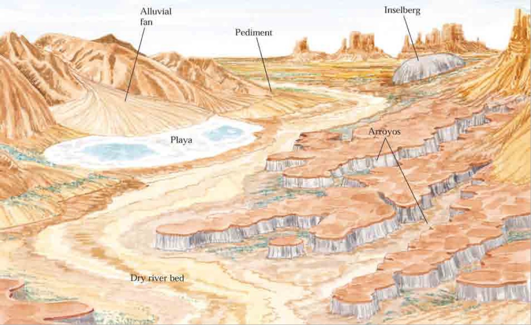 |
| Playa Location |
playa, (Spanish: shore or beach) , also called pan, flat, or dry lake, flat-bottom depression found in interior desert basins and adjacent to coasts within arid and semiarid regions, periodically covered by water that slowly filtrates into the ground water system or evaporates into the atmosphere, causing the deposition of salt, sand, and mud along the bottom and around the edges of the depression.
Playas are among the flattest known landforms. Their slopes are generally less than 0.2 metre per kilometre. When filled with only a few centimetres of water, many kilometres of surface may be inundated. It is the process of inundation that develops and maintains the near-perfect flatness so characteristic of these arid-region landforms.
Playas occupy the flat central basins of desert plains. They require interior drainage to a zone where evaporation greatly exceeds inflow. When flooded, a playa lake forms where fine-grained sediment and salts concentrate. Terminology is quite confused for playas because of many local names. A saline playa may be called a salt flat, salt marsh, salada, salar, salt pan, alkali flat, or salina. A salt-free playa may be termed a clay pan, hardpan, dry lake bed, or alkali flat. In Australia and South Africa small playas are generally referred to as pans. The low-relief plains of these lands contrast with the mountainous deserts of North America, resulting in numerous small pans instead of immense playas. The terms takyr, sabkha, and kavir are applied in Central Asia, Saudi Arabia, and Iran, respectively.

Physical characteristics
Enclosed basins of salt and clay accumulation may originate from numerous causes. Tectonic causes include faulting, as in the East African Rift Valley and Death Valley, and warping, as in Lake Eyre in Australia, Lake Chad in central Africa, and Shaṭṭ al-Jarīd (Chott Djerid) in Tunisia. Wind deflation can produce shallow basins with downwind dunes, as in southeastern Australia. Even very large basins, such as the Qattara Depression of Egypt, have been ascribed to deflation. Local cataclysmic disruptions of drainage (e.g., volcanism, landslides, and meteorite impacts) may produce playas in desert regions.
Didwana is a playa. Other such playas are the Kuchaman, the Sargol and the Khatu lakes.
9. Consider the following Rivers:
1. Brahmani
2. Nagavali
3. Subarnarekha
4. Vamsadhara
Which of the above rise from the Eastern Ghats?
(a) 1 and 2
(b) 2 and 4
(c) 3 and 4
(d) 1 and 3
Note - The Peninsular Rivers - The main water divide in Peninsular India is formed by the Western Ghats, which runs from north to south close to the western coast. Most of the major rivers of the Peninsula, such as the Mahanadi, the Godavari, the Krishna and the Kaveri flow eastwards and drain into the Bay of Bengal. These rivers make deltas at their mouths. There are numerous small streams flowing west of the Western Ghats. The Narmada and the Tapi are the only long rivers, which flow west and make esturies. The drainage basins of the peninsular rivers are comparatively smaller in size.
Small Rivers Flowing towards the East
There are a large number of rivers flowing towards the east along with their tributaries. There are small rivers which join the Bay of Bengal, though small, these are important in their own right. The Subarnrekha, the Baitarni, the Brahmani, the Vamsadhara, the Penner, the Palar and the Vaigai are important rivers.
River (Catchment area sq. km)
Subarnarekha (19,296)
Baitarni (39,033)
Brahmani (2,770)
Penner (55,213)
Palar (17,870)
 |
| Small Rivers Flowing towards the East |
Subarnarekha River
- The Subarnarekha is one of the longest east-flowing interstate rivers.
- It begins at an elevation of 600 metres in Nagri hamlet in Jharkhand's Ranchi area.
- It is bounded on the north-west by the Chota Nagpur Plateau, on the south-west by the Brahmani basin, on the south by the Burhabalang basin, and on the south-east by the Bay of Bengal.
- Hundru Falls, which falls from a height of 98 metres, is produced along the Subarnarekha River.
- The numerous rock formations developed as a consequence of erosion by the constantly running water have contributed to the area's allure.
- The Kharkai, Roro, Kanchi, Harmu Nadi, Damra, Karru, Chinguru, Karakari, Gurma, Garra, Singaduba, Kodia, Dulunga, and Khaijori are the Subarnarekha's primary tributaries.
- The Subarnarekha basin spans the states of Jharkhand, Odisha, and a minor portion of West.
Baitarani River
- The Baitarani is a large east-flowing river in peninsular India that finally flows into the Bay of Bengal.
- The Baitarani flows through the Gonasika hills and through a stone shaped like a cow's nose.
- Following that, the river goes underground for almost half a kilometre and is not visible from the outside.
- The Baitarani is known as Guptaganga or Gupta Baitarani in the Indian state of Odisha.
- Baitarani's commencement is a short stretch of the boundary between the states of Odisha and Jharkhand.
- The Budhi, Kanjori, Ambajhara, Mushal, Kusei, and Salandi are Baitarani's tributaries.
- The vast part of the river basin is in the state of Odisha, with a little portion of the upper reach in the state of Jharkhand.
Brahmani River
- The Brahmani river originates in Nagri village in Jharkhand's Ranchi area at a height of around 600 metres and travels for 799 kilometres.
- The Baitarani river originates in the hills of Odisha's Keonjhar district at an elevation of around 900 metres and travels for around 365 kilometres.
- Both river systems join to form a single delta in the Bay of Bengal.
- Koel, Kuradhi, Mankara, Samakoi, Ramiala, Karo, Sankh, Rukura, Gohira, Tikira, Singdajhor, Nigra, Barjor, and Nandira are Brahmani tributaries.
- The Sankh originated on the Netarhat Plateau on the Jharkhand-Chhattisgarh border.
- The South Koel also begins in Jharkhand, on the other side of the Damodar River basin, in Lohardaga.
- The Chota Nagpur Plateau is home to these two sources.
- This basin's soils are classified as red and yellow, mixed red and black, red sandy, laterite, red loamy, coastal alluvium, salty, and forest.
Pennar River
- Pennar river begins in Karnataka's Nandi highlands' Chenna Kesava hills and flows for around 597 kilometres before draining into the Bay of Bengal.
- The Jayamangal, Kunder, Sagileru, Chitravati, Papagni, and Cheyyeru rivers are the river's primary tributaries.
- The Pennar and its tributaries watershed spans a section of the southern Deccan plateau, including the bulk of Andhra Pradesh's Rayalaseema region and a piece of Karnataka.
- The Kolar Plateau divides the Pennar watershed from the Kaveri, Ponnaiyar, and Palar river basins to the south.
- The Pennar River drains the northern side of the plateau.
- The two hill ranges to the south of the river are the Seshachalam and Paliconda mountains.
Palar River
- It starts in Karnataka's Chikkaballapur district and goes through Karnataka, Andhra Pradesh, and Tamil Nadu until entering the Bay of Bengal at Vayalur, south of Chennai.
- It flows underground for a long distance before surfacing in Bethamangala town and travelling eastward through the Deccan Plateau, accumulating water and speed.
- The flow of the Palar is unpredictable, with large variations from year to year.
- Although the river does not flood frequently, heavy rains have caused it to overflow for up to six months.
- The Palar River receives water from two major tributaries: the Ponni on the left bank and the Cheyyar on the right.
- The usual rainfall in the Palar river basin is low. Droughts were widespread in this river basin in the past. There has been no full-scale flow for the preceding 10 years.
Vamsadhara River
- It is an east-flowing river that begins in the Odisha district of Kalahandi, travels through Odisha, along the border with Andhra Pradesh, and ultimately meets the Bay of Bengal in Kalingapatnam, Andhra Pradesh.
- It is the primary river in the north-eastern Andhra region, and the Boddepalli Rajagopala Rao Project was built on it to suit the region's irrigation demands.
- The Mahendratanaya River is a significant tributary river of the Vamsadhara, originating in the Odisha district of Gajapati.
- The Regulapadu barrage in Andhra Pradesh is being built to redirect river water for agricultural purposes.
Damodar River
- The Damodar River runs through a rift valley after rising in the Palamau hills of Chota Nagpur at a height of around 609.75 m.
- It runs south-eastward, joining the deltaic plains below Raniganj. Near Burdwan, the river rapidly reverses course to the south and enters the Hooghly about 48.27 kilometres below Calcutta.
- Barakar, Konar, Bokaro, Haharo, Jamunia, Ghari, Guaia, Khadia, and Bhera are some of its tributaries.
- The Damodar River's main tributary is the Barakar. The source of the Barakar lies in the Hazaribagh area, near the Padma.
- Previously known as the Sorrow of Bengal due to the devastation caused by floods in West Bengal's lowlands.
Vaigai River
- The Vaigai is a river in the Indian state of Tamil Nadu that flows through the towns of Theni, Dindigul, and Madurai.
- It runs northeast from the Varusanadu Hills, the Periyar Plateau of the Western Ghats range, through the Kambam Valley, which is located between the Palani Hills to the north and the Varusanadu Hills to the south.
- This river is home to the Vattaparai Falls.
- The two major left bank tributaries are the Suruliyar and the Manjalar.
- The Vaigai river basin is mostly composed of hard crystalline rock masses of archaean age on the western side, and sedimentary rocks of upper Gondwana, tertiary, and quaternary age on the eastern side.
10. Among the following, which one is the least water-efficient crop?
(a) Sugarcane
(b) Sunflower
(c) Pearl millet
(d) Red gram
Note - Sugarcane is the least water-efficient crop. Sugarcane requires a lot of water for its growth and irrigation, and it is estimated that it takes around 2000 to 2500 liters of water to produce 1 kg of sugarcane. In comparison, pearl millet, sunflower, and red gram are relatively more water-efficient crops.
गन्ना सबसे कम पानी बचाने वाली फसल है। गन्ने की वृद्धि और सिंचाई के लिए बहुत अधिक पानी की आवश्यकता होती है और अनुमान है कि 1 किलो गन्ना पैदा करने में लगभग 2000 से 2500 लीटर पानी लगता है। इसकी तुलना में, बाजरा, सूरजमुखी, और लाल चना अपेक्षाकृत अधिक जल-कुशल फसलें हैं।
 |
| Sugarcane Crop |
11. Consider the following statements:
1. In the tropical zone, the western sections of the oceans are warmer than the eastern sections owing to the influence of trade winds.
2. In the temperate Zone, westerlies make the eastern sections of oceans warmer than the western sections
Which of the statements given above is/are correct?
(a) 1 only
(b) 2 only
(c) Both 1 and 2
(d) Neither 1 and 2
Note -
1) In the tropical zone, the western sections of the oceans are warmer than the eastern sections owing to the influence of trade winds.
- Trade winds blow from the east towards the west in the tropical zone, pushing the surface water towards the western sections of the oceans.
- This results in the piling up of warm surface water in the western sections, making them warmer than the eastern sections.
- The warm water in the western sections also leads to the development of coral reefs and high biodiversity.
 |
| Trade winds |
2) In the temperate zone, westerlies make the eastern sections of oceans warmer than the western sections.
- Westerlies blow from the west towards the east in the temperate zone, pushing the surface water towards the eastern sections of the oceans.
- This results in the piling up of warm surface water in the eastern sections, making them warmer than the western sections.
- The warm water in the eastern sections also leads to the development of marine ecosystems and fisheries.
 |
| westerlies trade winds |

12. “Leaf litter decomposes faster than in any other biome and as a result, the soil surface is often almost bare. Apart from trees, the vegetation is largely composed of plant forms that reach up into the canopy vicariously, by climbing the trees or growing as epiphytes, rooted on the upper branches of trees.” This is the most likely description of
(a) Coniferous forest
(b) Dry deciduous forest
(c) Mangrove forest
(d) Tropical rain forest
 |
| Tropical Rain forest |