Besides the longitudinal divisions, the Himalayas have been divided on the basis of regions from west to east. These divisions have been demarcated by river valleys.
For example, the part of Himalayas lying between Indus and Satluj has been traditionally known as Punjab Himalaya, but it is also known regionally as Kashmir and Himachal Himalaya from west to east respectively.
The part of the Himalayas lying between Satluj and Kali rivers is known as Kumaon Himalayas.
The Kali and Teesta rivers demarcate the Nepal Himalayas and the part lying between Teesta and Dihang rivers is known as Assam Himalayas. There are regional names also in these broad categories.
There are large-scale regional variations within the Himalayas. On the basis of relief, alignment of ranges and other geomorphological features, the Himalayas can be divided into the following sub-divisions:
(i) Kashmir or Northwestern Himalayas
(ii) Himachal and Uttarakhand Himalayas
(iii) Darjiling and Sikkim Himalayas
(iv) Arunachal Himalayas
(v) Eastern Hills and Mountains.
(a) Kashmir or Northwestern Himalayas
It comprise a series of ranges such as the Karakoram, Ladakh, Zaskar and Pir Panjal. The northeastern part of the Kashmir Himalayas is a cold desert, which lies between the Greater Himalayas and the Karakoram ranges.
Between the Great Himalayas and the Pir Panjal range, lies the world famous valley of Kashmir and the famous Dal Lake. Important glaciers of South Asia such as the Baltoro and Siachen are also found in this region.
 |
| Meandering Jhelum |
(b) The Himachal and Uttarakhand Himalayas
This part lies approximately between the Ravi in the west and the Kali (a tributary of Ghaghara) in the east. It is drained by two major river systems of India, i.e. the Indus and the Ganga. Tributaries of the Indus include the river Ravi, the Beas and the Satluj, and the tributaries of Ganga flowing through this region include the Yamuna and the Ghaghara.
The northernmost part of the Himachal Himalayas is an extension of the Ladakh cold desert, which lies in the Spiti subdivision of district Lahul and Spiti.
All the three ranges of Himalayas are prominent in this section also. These are the Great Himalayan range, the Lesser Himalayas (which is locally known as Dhaoladhar in Himachal Pradesh and Nagtibha in Uttarakhand) and the Shiwalik range from the North to the South. In this section of Lesser Himalayas, the altitude between 1,000-2,000 m specially attracted to the British colonial administration, and subsequently, some of the important hill stations such as Dharamshala, Mussoorie, Shimla, Kaosani and the cantonment towns and health resorts such as Shimla, Mussoorie, Kasauli, Almora, Lansdowne and Ranikhet, etc. were developed in this region.
The two distinguishing features of this region from the point of view of physiography are the ‘Shiwalik’ and ‘Dun formations'. Some important duns located in this region are the Chandigarh-Kalka dun, Nalagarh dun, Dehra Dun, Harike dun and the Kota dun, etc. Dehra Dun is the largest of all the duns with an approximate length of 35-45 km and a width of 22-25 km.
In the Great Himalayan range, the valleys are mostly inhabited by the Bhotia’s. These are nomadic groups who migrate to ‘Bugyals’ (the summer glasslands in the higher reaches) during summer months and return to the valleys during winters. The famous ‘Valley of flowers’ is also situated in this region. The places of pilgrimage such as the Gangotri, Yamunotri, Kedarnath, Badrinath and Hemkund Sahib are also situated in this part.
The region is also known to have five famous Prayags (river confluences). The source of the Alaknanda River is the Sotpath Glacier above Badrinath. The Alaknanda itself is formed by the Dhauli and Vishnuganga streams, which meet at Joshimath or Vishnu Prayag. Another tributary of the Alaknanda is the Pindar, which joins it at Karnaprayag, while the Mandakini and the Kali Ganga join it at Rudraprayag. The confluence of Bhagirathi River and Alaknanda rivers is called Devprayag, from where these rivers get their name Ganga.
 |
| Panch Prayag |
The Shiwalik
The word shiwalik has its origin in the geological formation found in and around a place called Sivawala near Dehra Dun which was once a headquarter of the Imperial Survey and which subsequently established its permanent headquarters at Dehra Dun.
(c) The Darjiling and Sikkim Himalayas
They are flanked by Nepal Himalayas in the west and Bhutan Himalayas in the east. It is relatively small but is a most significant part of the Himalayas. Known for its fast-flowing rivers such as Tista, it is a region of high mountain peaks like Kanchenjunga (Kanchengiri), and deep valleys.
The higher reaches of this region are inhabited by Lepcha tribes while the southern part, particularly the Darjiling Himalayas, has a mixed population of Nepalis, Bengalis and tribals from Central India.
The British, taking advantage of the physical conditions such as moderate slope, thick soil cover with high organic content, well distributed rainfall throughout the year and mild winters, introduced tea plantations in this region.
As compared to the other sections of the Himalayas, these along with the Arunachal Himalayas are conspicuous by the absence of the Shiwalik formations. In place of the Shiwaliks here, the ‘duar formations’ are important, which have also been used for the development of tea gardens.
Sikkim and Darjiling Himalayas are also known for their scenic beauty and rich flora and fauna, particularly various types of orchids.
(d) The Arunachal Himalayas
These extend from the east of the Bhutan Himalayas up to the Diphu pass in the east. The general direction of the mountain range is from southwest to northeast.

Some of the important mountain peaks of the region are Kangtu and Namcha Barwa (7756 m).
These ranges are dissected by fast-flowing rivers from the north to the south, forming deep gorges. Bhramaputra flows through a deep gorge after crossing Namcha Barwa. Some of the important rivers are the Kameng, the Subansiri, the Dihang, the Dibang and the Lohit. These are perennial with the high rate of fall, thus, having the highest hydro-electric power potential in the country.
 |
| Rivers of Northeast India |
An important aspect of the Arunachal Himalayas is the numerous ethnic tribal communities inhabiting in these areas. Some of the prominent ones from west to east are the Monpa, Abor, Mishmi, Nyishi and the Nagas. Most of these communities practise Jhumming. It is also known as shifting or slash and burn cultivation.
This region is rich in biodiversity which has been preserved by the indigenous communities. Due to rugged topography, the inter-valley transportation linkages are nominal. Hence, most of the interactions are carried through the duar region along the Arunachal-Assam border.
(e) The Eastern Hills and Mountains
These are part of the Himalayan Mountain system having their general alignment from the north to the south direction. They are known by different local names. In the north, they are known as Patkai Bum, Naga hills, the Manipur hills and in the south as Mizo or Lushai hills. These are low hills, inhabited by numerous tribal groups practising Jhum cultivation.
 |
| The Eastern Hills and Eastern Himalayas Mountains |
Most of these ranges are separated from each other by numerous small rivers. The Barak is an important river in Manipur and Mizoram. The physiography of Manipur is unique by the presence of a large lake known as ‘Loktak’ lake at the centre, surrounded by mountains from all sides.
 |
| loktak - The floating-lake in Manipur |
Mizoram which is also known as the ‘Molassis basin’ which is made up of soft unconsolidated deposits. Most of the rivers in Nagaland form the tributary of the Brahmaputra. While two rivers of Mizoram and Manipur are the tributaries of the Barak River, which in turn is the tributary of Meghna; the rivers in the eastern part of Manipur are the tributaries of Chindwin, which in turn is a tributary of the Irrawady of Myanmar.
अनुदैर्ध्य विभाजनों के अलावा हिमालय को पश्चिम से पूर्व तक के क्षेत्रों के आधार पर भी विभाजित किया गया है। इन प्रभागों को नदी घाटियों द्वारा सीमांकित किया गया है।
उदाहरण के लिए, सिंधु और सतलुज के बीच स्थित हिमालय का हिस्सा पारंपरिक रूप से पंजाब हिमालय के रूप में जाना जाता है, लेकिन इसे क्षेत्रीय रूप से पश्चिम से पूर्व तक क्रमशः कश्मीर और हिमाचल हिमालय के रूप में भी जाना जाता है।
सतलुज और काली नदियों के बीच स्थित हिमालय का भाग कुमाऊँ हिमालय के नाम से जाना जाता है।
काली और तीस्ता नदियाँ नेपाल हिमालय का सीमांकन करती हैं और तीस्ता और दिहांग नदियों के बीच का भाग असम हिमालय के रूप में जाना जाता है। इन व्यापक श्रेणियों में क्षेत्रीय नाम भी हैं।
ब्रह्मपुत्र हिमालय की सबसे पूर्वी सीमा को चिह्नित करती है। दिहांग कण्ठ से परे, हिमालय तेजी से दक्षिण की ओर झुकता है और भारत की पूर्वी सीमा तक फैल जाता है। इन्हें पूर्वाचल या पूर्वी पहाड़ियों और पर्वतों के नाम से जाना जाता है। उत्तर-पूर्वी राज्यों से होकर गुजरने वाली ये पहाड़ियाँ ज्यादातर मजबूत बलुआ पत्थरों से बनी हैं, जो तलछटी चट्टानें हैं। घने जंगलों से आच्छादित, ये अधिकतर समानांतर पर्वतमालाओं और घाटियों के रूप में फैले हुए हैं। पूर्वाचल में पटकाई पहाड़ियाँ, नागा पहाड़ियाँ, मणिपुर पहाड़ियाँ और मिज़ो पहाड़ियाँ शामिल हैं।
हिमालय के भीतर बड़े पैमाने पर क्षेत्रीय विविधताएँ हैं। राहत, श्रेणियों के संरेखण और अन्य भू-आकृति संबंधी विशेषताओं के आधार पर, हिमालय को निम्नलिखित उप-विभाजनों में विभाजित किया जा सकता है:
(i) कश्मीर या उत्तर-पश्चिमी हिमालय
(ii) हिमाचल और उत्तराखंड हिमालय
(iii) दार्जिलिंग और सिक्किम हिमालय
(iv) अरुणाचल हिमालय
(v) पूर्वी पहाड़ियाँ और पर्वत।
(ए) कश्मीर या उत्तर-पश्चिमी हिमालय
इसमें काराकोरम, लद्दाख, जास्कर और पीर पंजाल जैसी श्रृंखलाएं शामिल हैं। कश्मीर हिमालय का उत्तरपूर्वी भाग एक ठंडा रेगिस्तान है, जो वृहत हिमालय और काराकोरम पर्वतमाला के बीच स्थित है।
महान हिमालय और पीर पंजाल श्रृंखला के बीच, कश्मीर की विश्व प्रसिद्ध घाटी और प्रसिद्ध डल झील स्थित है। दक्षिण एशिया के महत्वपूर्ण ग्लेशियर जैसे बाल्टोरो और सियाचिन भी इसी क्षेत्र में पाए जाते हैं।
कश्मीर हिमालय करेवा संरचनाओं के लिए भी प्रसिद्ध है (करेवा हिमानी मिट्टी और मोराइन से युक्त अन्य सामग्रियों के मोटे भंडार हैं।), जो केसर की एक स्थानीय किस्म, ज़ाफ़रान की खेती के लिए उपयोगी हैं।
इस क्षेत्र के कुछ महत्वपूर्ण दर्रे हैं महान हिमालय पर ज़ोजी ला, पीर पंजाल पर बनिहाल, जास्कर पर फोटू ला और लद्दाख रेंज पर खारदुंग ला।
कुछ महत्वपूर्ण ताज़ा झीलें जैसे डल और वुलर और खारे पानी की झीलें जैसे पैंगोंग त्सो और त्सो मोरीरी भी इसी क्षेत्र में हैं।
यह क्षेत्र सिंधु नदी और उसकी सहायक नदियों जैसे झेलम और चिनाब द्वारा सिंचित होता है।
कश्मीर और उत्तर-पश्चिमी हिमालय अपनी प्राकृतिक सुंदरता और सुरम्य परिदृश्य के लिए प्रसिद्ध हैं। हिमालय का परिदृश्य साहसिक पर्यटकों के लिए आकर्षण का एक प्रमुख स्रोत है।
कुछ प्रसिद्ध तीर्थ स्थान जैसे वैष्णो देवी, अमरनाथ गुफा, चरार-ए-शरीफ़ आदि भी यहाँ स्थित हैं और हर साल बड़ी संख्या में तीर्थयात्री इन स्थानों पर जाते हैं।
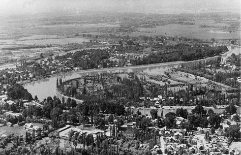
जम्मू और कश्मीर राज्य की राजधानी श्रीनगर झेलम नदी के तट पर स्थित है।
श्रीनगर में डल झील एक दिलचस्प भौतिक विशेषता प्रस्तुत करती है। कश्मीर की घाटी में झेलम अभी भी अपने युवा चरण में है और अभी भी घुमावदार रूप बनाती है - नदी के भू-आकृति के विकास में परिपक्व चरण से जुड़ी एक विशिष्ट विशेषता। कश्मीर घाटी में, झेलम नदी में घुमाव तत्कालीन बड़ी झील द्वारा प्रदान किए गए स्थानीय आधार स्तर के कारण होता है, जिसका वर्तमान डल झील एक छोटा सा हिस्सा है।
इस क्षेत्र के सबसे दक्षिणी भाग में अनुदैर्ध्य घाटियाँ हैं जिन्हें 'डन' के नाम से जाना जाता है। जम्मू दून और पठानकोट दून इसके महत्वपूर्ण उदाहरण हैं।
(बी) हिमाचल और उत्तराखंड हिमालय
यह भाग लगभग पश्चिम में रावी और पूर्व में काली (घाघरा की एक सहायक नदी) के बीच स्थित है। यह भारत की दो प्रमुख नदी प्रणालियों अर्थात् सिंधु और गंगा द्वारा अपवाहित होती है। सिंधु की सहायक नदियों में रावी, ब्यास और सतलुज नदी शामिल हैं, और इस क्षेत्र से बहने वाली गंगा की सहायक नदियों में यमुना और घाघरा शामिल हैं।
हिमाचल हिमालय का सबसे उत्तरी भाग लद्दाख ठंडे रेगिस्तान का विस्तार है, जो जिला लाहुल और स्पीति के स्पीति उपखंड में स्थित है।
इस खण्ड में भी हिमालय की तीनों श्रेणियाँ प्रमुख हैं। ये हैं महान हिमालय श्रृंखला, लघु हिमालय (जिसे स्थानीय रूप से हिमाचल प्रदेश में धौलाधार और उत्तराखंड में नागतिभा के नाम से जाना जाता है) और उत्तर से दक्षिण तक शिवालिक श्रृंखला है। लघु हिमालय के इस खंड में, 1,000-2,000 मीटर के बीच की ऊंचाई विशेष रूप से ब्रिटिश औपनिवेशिक प्रशासन को आकर्षित करती थी, और बाद में, धर्मशाला, मसूरी, शिमला, काओसानी जैसे कुछ महत्वपूर्ण हिल स्टेशन और शिमला जैसे छावनी शहर और स्वास्थ्य रिसॉर्ट्स , मसूरी, कसौली, अल्मोडा, लैंसडाउन तथा रानीखेत आदि का विकास इसी क्षेत्र में हुआ।
भौतिक विज्ञान की दृष्टि से इस क्षेत्र की दो विशिष्ट विशेषताएं 'शिवालिक' और 'दून संरचनाएं' हैं। इस क्षेत्र में स्थित कुछ महत्वपूर्ण दून हैं: चंडीगढ़-कालका दून, नालागढ़ दून, देहरादून, हरिके दून और कोटा दून आदि। सभी दून में से देहरादून सबसे बड़ा है, जिसकी लंबाई लगभग 35-45 किमी और चौड़ाई है। 22-25 कि.मी.
महान हिमालय श्रृंखला में, घाटियाँ ज्यादातर भोटिया लोगों द्वारा बसाई गई हैं। ये खानाबदोश समूह हैं जो गर्मियों के महीनों के दौरान 'बुग्यालों' (ऊपरी इलाकों में ग्रीष्मकालीन ग्लासलैंड) की ओर पलायन करते हैं और सर्दियों के दौरान घाटियों में लौट आते हैं। प्रसिद्ध 'फूलों की घाटी' भी इसी क्षेत्र में स्थित है। गंगोत्री, यमुनोत्री, केदारनाथ, बद्रीनाथ और हेमकुंड साहिब जैसे तीर्थस्थल भी इसी भाग में स्थित हैं।
यह क्षेत्र पाँच प्रसिद्ध प्रयागों (नदी संगम) के लिए भी जाना जाता है। अलकनंदा नदी का स्रोत बद्रीनाथ के ऊपर सोतपथ ग्लेशियर है। अलकनंदा स्वयं धौली और विष्णुगंगा धाराओं से निर्मित होती है, जो जोशीमठ या विष्णु प्रयाग में मिलती हैं। अलकनंदा की एक अन्य सहायक नदी पिंडर है, जो कर्णप्रयाग में इसमें मिलती है, जबकि मंदाकिनी और काली गंगा रुद्रप्रयाग में इसमें मिलती है। भागीरथी नदी और अलकनंदा नदियों के संगम को देवप्रयाग कहा जाता है, जहाँ से इन नदियों का नाम गंगा पड़ा।
शिवालिक
शिवालिक शब्द की उत्पत्ति देहरादून के पास शिववाला नामक स्थान में और उसके आसपास पाए जाने वाले भूवैज्ञानिक गठन से हुई है, जो कभी इंपीरियल सर्वे का मुख्यालय था और जिसने बाद में देहरादून में अपना स्थायी मुख्यालय स्थापित किया था।
(सी) दार्जिलिंग और सिक्किम हिमालय
वे पश्चिम में नेपाल हिमालय और पूर्व में भूटान हिमालय से घिरे हुए हैं। यह अपेक्षाकृत छोटा है लेकिन हिमालय का सबसे महत्वपूर्ण हिस्सा है। यह तिस्ता जैसी तेज़ बहने वाली नदियों के लिए जाना जाता है, यह कंचनजंगा (कंचेनगिरी) जैसी ऊंची पर्वत चोटियों और गहरी घाटियों का क्षेत्र है।
इस क्षेत्र के ऊंचे इलाकों में लेप्चा जनजातियाँ निवास करती हैं, जबकि दक्षिणी भाग, विशेष रूप से दार्जिलिंग हिमालय में, नेपालियों, बंगालियों और मध्य भारत के आदिवासियों की मिश्रित आबादी है।
ब्रिटिशों ने मध्यम ढलान, उच्च कार्बनिक सामग्री के साथ मोटी मिट्टी के आवरण, पूरे वर्ष अच्छी तरह से वितरित वर्षा और हल्की सर्दियों जैसी भौतिक स्थितियों का लाभ उठाते हुए, इस क्षेत्र में चाय बागान शुरू किए।
हिमालय के अन्य खंडों की तुलना में, ये अरुणाचल हिमालय के साथ-साथ शिवालिक संरचनाओं की अनुपस्थिति के कारण विशिष्ट हैं। यहां शिवालिक के स्थान पर 'डुअर संरचनाएं' महत्वपूर्ण हैं, जिनका उपयोग चाय बागानों के विकास के लिए भी किया गया है।
सिक्किम और दार्जिलिंग हिमालय अपनी प्राकृतिक सुंदरता और समृद्ध वनस्पतियों और जीवों, विशेष रूप से विभिन्न प्रकार के ऑर्किड के लिए भी जाने जाते हैं।
(डी) अरुणाचल हिमालय
ये भूटान हिमालय के पूर्व से लेकर पूर्व में दीफू दर्रे तक फैले हुए हैं। पर्वत श्रृंखला की सामान्य दिशा दक्षिण-पश्चिम से उत्तर-पूर्व की ओर है।
इस क्षेत्र की कुछ महत्वपूर्ण पर्वत चोटियाँ कांगटू और नामचा बरवा (7756 मीटर) हैं।
ये श्रेणियाँ उत्तर से दक्षिण की ओर तेजी से बहने वाली नदियों द्वारा विच्छेदित होती हैं, जिससे गहरी घाटियाँ बनती हैं। नामचा बरवा को पार करने के बाद ब्रह्मपुत्र एक गहरी घाटी से होकर बहती है। कुछ महत्वपूर्ण नदियाँ कामेंग, सुबनसिरी, दिहांग, दिबांग और लोहित हैं। ये गिरावट की उच्च दर के साथ बारहमासी हैं, इस प्रकार, देश में सबसे अधिक पनबिजली क्षमता रखते हैं।
पूर्वोत्तर भारत की नदियाँ
अरुणाचल हिमालय का एक महत्वपूर्ण पहलू इन क्षेत्रों में रहने वाले असंख्य जातीय जनजातीय समुदाय हैं। पश्चिम से पूर्व तक कुछ प्रमुख हैं मोनपा, अबोर, मिश्मी, न्यीशी और नागा। इनमें से अधिकांश समुदाय झूमिंग का अभ्यास करते हैं। इसे स्थानांतरण या स्लैश एंड बर्न खेती के रूप में भी जाना जाता है।
यह क्षेत्र जैव विविधता से समृद्ध है जिसे स्वदेशी समुदायों द्वारा संरक्षित किया गया है। ऊबड़-खाबड़ स्थलाकृति के कारण, अंतर-घाटी परिवहन संपर्क नाममात्र का है। इसलिए, अधिकांश बातचीत अरुणाचल-असम सीमा के साथ दुआर क्षेत्र के माध्यम से की जाती है।
(ई) पूर्वी पहाड़ियाँ और पर्वत
ये हिमालय पर्वत प्रणाली का हिस्सा हैं जिनका सामान्य संरेखण उत्तर से दक्षिण दिशा की ओर है। इन्हें अलग-अलग स्थानीय नामों से जाना जाता है। उत्तर में इन्हें पटकाई बम, नागा पहाड़ियाँ, मणिपुर पहाड़ियाँ और दक्षिण में मिज़ो या लुशाई पहाड़ियाँ के नाम से जाना जाता है। ये निचली पहाड़ियाँ हैं, जहाँ झूम खेती करने वाले कई आदिवासी समूह रहते हैं।
इनमें से अधिकांश श्रेणियाँ अनेक छोटी-छोटी नदियों द्वारा एक-दूसरे से अलग होती हैं। बराक मणिपुर और मिजोरम की एक महत्वपूर्ण नदी है। मणिपुर की भौगोलिक संरचना केंद्र में 'लोकटक' झील के नाम से मशहूर एक बड़ी झील की उपस्थिति से अद्वितीय है, जो चारों ओर से पहाड़ों से घिरी हुई है।
मिज़ोरम जिसे 'मोलासिस बेसिन' के नाम से भी जाना जाता है जो नरम असंगठित निक्षेपों से बना है। नागालैंड की अधिकांश नदियाँ ब्रह्मपुत्र की सहायक नदी हैं। जबकि मिजोरम और मणिपुर की दो नदियाँ बराक नदी की सहायक नदियाँ हैं, जो बदले में मेघना की सहायक नदी है; मणिपुर के पूर्वी भाग की नदियाँ चिंडविन की सहायक नदियाँ हैं, जो बदले में म्यांमार की इरावदी की सहायक नदी हैं।
You Can Also Visit...
Map of Indian Physical Divisions and Relief
Physiographic divisions of India भारत के भौगोलिक खंड
The North and Northeastern Mountains उत्तर और उत्तरपूर्वी पर्वत
Regional Classification of the Himalayas हिमालय का प्रादेशिक वर्गीकरण
The Northern Plains उत्तरी मैदान
The Peninsular Plateau प्रायद्वीपीय पठार
The Indian Desert - Thar Desert भारतीय मरुस्थल - थार रेगिस्तान
The Coastal Plains तटीय मैदान
The Islands द्वीपसमूह