The Coastal Plains
You have already read that India has a long (6100 km + 1416.6 km = 7516.6 kms) coastline. On the basis of the location and active geomorphological processes, it can be broadly divided into two: (i) the western coastal plains; (ii) the eastern coastal plains.
 |
| the city of Dwaraka |
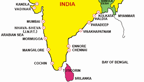
The western coastal plains are an example of submerged coastal plain. It is believed that the city of Dwaraka which was once a part of the Indian mainland situated along the west coast is submerged under water. Because of this submergence it is a narrow belt and provides natural conditions for the development of ports and harbours. Kandla, Mazagaon, JLN port Navha Sheva, Marmagao, Mangalore, Cochin, etc. are some of the important natural ports located along the west coast.
 |
| Major Sea Port of India |
Extending from the Gujarat coast in the north to the Kerala coast in the south, the western coast may be divided into following divisions – the Kachchh and Kathiawar coast in Gujarat, Konkan coast in Maharashtra, Goan coast and Malabar coast in Karnataka and Kerala respectively.
 |
| The Coastal Plains of India |
The western coastal plains are narrow in the middle and get broader towards north and south. The rivers flowing through this coastal plain do not form any delta.
 |
| Vembanad Kayal |
The Malabar coast has got certain distinguishing features in the form of ‘Kayals’ (backwaters), which are used for fishing, inland navigation and also due to its special attraction for tourists. Every year the famous Nehru Trophy Vallamkali (boat race) is held in Punnamada Kayal in Kerala.
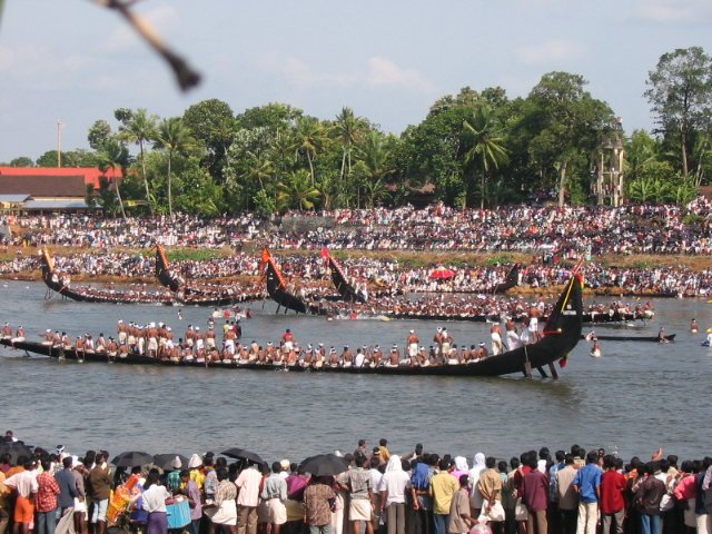 |
| Nehru Trophy Vallamkali (boat race) Punnamada Kayal, Alappuzha, Kerala |
As compared to the western coastal plain, the eastern coastal plain is broader and is an example of an emergent coast.
 |
| Emergent coast |
There are well-developed deltas here, formed by the rivers flowing eastward into the Bay of Bengal. These include the deltas of the Mahanadi, the Godavari, the Krishna and the Kaveri. Because of its emergent nature, it has a smaller number of ports and harbours.
 |
| Delta of East flowing rivers along with the coast of the Bay of Bengal |
The continental shelf extends up to 500 km into the sea, which makes it difficult for the development of good ports and harbours.
 |
| The continental shelf with the Bay of Bengal |
Name some ports on the eastern coast.
तटीय मैदान
आप पहले ही पढ़ चुके हैं कि भारत की तट रेखा बहुत लंबी है। स्थिति और सक्रिय भूआकृतिक प्रक्रियाओं के आधार पर तटीय मैदानों को दो भागों में बाँटा जा सकता है; (i) पश्चिमी तटीय मैदान (ii) पूर्वी तटीय मैदान।
पश्चिमी तटीय मैदान जलमग्न तटीय मैदानों के उदाहरण हैं। एेसा विश्वास है कि पौराणिक शहर द्वारका, जो किसी समय पश्चिमी तट पर मुख्य भूमि पर स्थित था, अब पानी में डूबा हुआ है। जलमग्न होने के कारण पश्चिमी तटीय मैदान एक संकीर्ण पट्टी मात्र है और पत्तनों एवं बंदरगाह विकास के लिए प्राकृतिक परिस्थितियाँ प्रदान करता है। यहाँ पर स्थित प्राकृतिक बंदरगाहों में कांडला, मजगाँव, जे एल एन नावहा शेवा, मर्मागाओ, मैंगलौर, कोचीन शामिल हैं। उत्तर में गुजरात तट से, दक्षिण में केरल तट तक फैले पश्चिमी तटीय मैदान को निम्नलिखित भागों में विभाजित किया जा सकता है–गुजरात का कच्छ और काठियावाड़ तट, महाराष्ट्र का कोंकण तट और गोवा तट, कर्नाटक तथा केरल के क्रमशः मालाबार तट। पश्चिमी तटीय मैदान मध्य में संकीर्ण है परंतु उत्तर और दक्षिण में चौड़े हो जाते हैं। इस तटीय मैदान में बहने वाली नदियाँ डेल्टा नहीं बनाती हैं। मालाबार तट की विशेष स्थलाकृति ‘कयाल’ (Backwaters) जिसे मछली पकड़ने और अंतःस्थलीय नौकायन के लिए प्रयोग किया जाता है और पर्यटकों के लिए विशेष आकर्षण का केंद्र है। केरल में हर वर्ष प्रसिद्ध ‘नेहरू ट्राफी वलामकाली’ (नौका दौड़) का आयोजन ‘पुन्नामदा कयाल’ में किया जाता है।
पश्चिमी तटीय मैदान की तुलना में पूर्वी तटीय मैदान चौड़ा है और उभरे हुए तट का उदाहरण है। पूर्व की ओर बहने वाली और बंगाल की खाड़ी में गिरने वाली नदियाँ यहाँ लम्बे-चौड़े डेल्टा बनाती हैं।इसमें महानदी, गोदावरी, कृष्णा और कावेरी का डेल्टा शामिल है। उभरा तट होने के कारण यहाँ पत्तन और पोता श्रय कम हैं। यहाँ पर महाद्वीपीय शेल्फ की चौड़ाई 500 किलोमीटर है जिसके कारण यहाँ पत्तनों और पोताश्रयों का विकास मुश्किल है।पूर्वी तट के कुछ पत्तनों के नाम बताइए।
You Can Also Visit...
Map of Indian Physical Divisions and ReliefPhysiographic divisions of India भारत के भौगोलिक खंड
The North and Northeastern Mountains उत्तर और उत्तरपूर्वी पर्वत
Regional Classification of the Himalayas हिमालय का प्रादेशिक वर्गीकरण
The Northern Plains उत्तरी मैदान
The Peninsular Plateau प्रायद्वीपीय पठार
The Indian Desert - Thar Desert भारतीय मरुस्थल - थार रेगिस्तान
The Coastal Plains तटीय मैदान
The Islands द्वीपसमूह