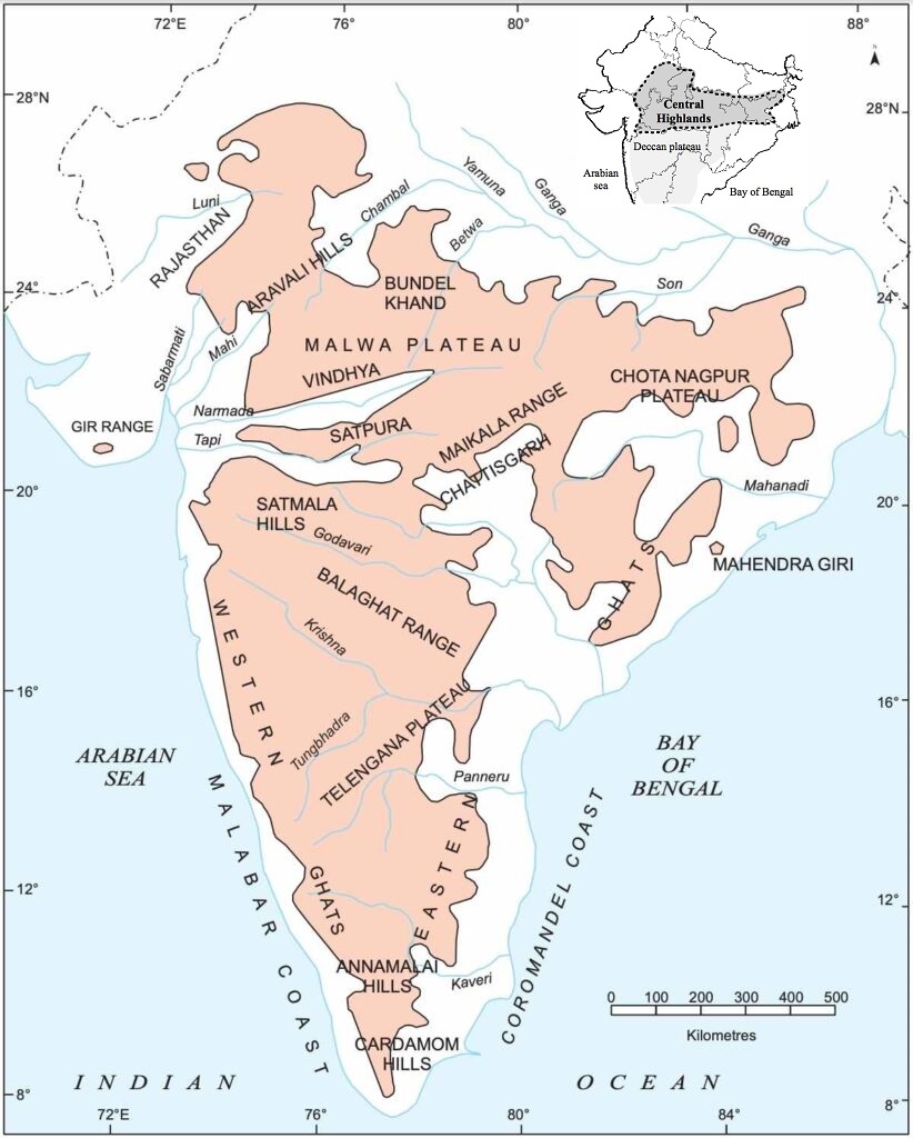
The Peninsular Plateau
Rising from the height of 150 m above the river plains (North Indian Plains) up to an elevation of 600-900 m is the irregular triangle known as the Peninsular plateau. Delhi ridge in the northwest, (extension of Aravalis), the Rajmahal hills in the east, Gir range in the west and the Cardamom hills in the south constitute the outer extent of the Peninsular plateau. However, an extension of this is also seen in the northeast, in the form of Shillong and Karbi-Anglong plateau.
 |
| The outer extent of the Peninsular plateau |
The Peninsular India is made up of a series of patland plateaus such as the Hazaribagh plateau, the Palamu plateau, the Ranchi plateau, the Malwa plateau, the Coimbatore plateau and the Karnataka plateau, etc.
This is one of the oldest and the most stable landmass of India. The general elevation of the plateau is from the west to the east, which is also proved by the pattern of the flow of rivers.
Name some rivers of the Peninsular plateau which have their confluence in the Bay of Bengal and the Arabian sea and mention some landforms which are typical to the east flowing rivers but are absent in the west flowing rivers.
Note - The peninsular drainage into the Bay of Bengal includes a number of major rivers, most notably the Mahanadi, Godavari, Krishna, and Kaveri. Narmada and Tapi are the only two major peninsular rivers that empty into the Arabian sea. The Western Ghats act as a water divide between east flowing river and west flowing river. Delta is the main landform which are typical made by the east flowing rivers of peninsular rivers but are absent in the west flowing rivers. West flowing rivers Narmada and Tapi forms the estuary at their mouth.
Some of the important physiographic features of this region are tors (Tors are a free-standing rocky landform created by the erosion and weathering of rock; most commonly granites, but also schists, dacites, dolerites, ignimbrites, coarse sandstones and others. Tors are mostly less than 5 meters (16 ft) high.),
 |
| Kit-Mikayi Tor in Western Kenya |
 |
| Pachmarhi Valley in Madhya Pradesh - An Example of Block Mountain and Rift Valley |
spurs (A spur is a lateral ridge or tongue of land descending from a hill, mountain or main crest of a ridge. It can also be defined as another hill or mountain range which projects in a lateral direction from a main hill or mountain range.),
 |
| A spur (पर्वत स्कंध) in the Tatra Mountains |
bare rocky structures,
 |
| Bare rocky structures (नग्न चट्टान संरचना) |
series of hummocky hills (टेकरी पहाड़ी शृंखलाएँ) (a hummock is a small knoll or mound above ground. They are typically less than 15 meters (50 ft) in height and tend to appear in groups or fields. An extremely irregular surface may be called hummocky. An ice hummock is a boss or rounded knoll of ice rising above the general level of an icefield.)
 |
| Series of hummocky hills - An extremely irregular surface. |
and wall-like quartzite dykes offering natural sites for water storage.
 |
| Sill and Dyke |
The western and northwestern part of the plateau has an emphatic presence of black soil.
 |
| Major Soil Types of India |
 |
| Satellite image of a fault in the Taklamakan Desert. |
(The Bhima fault needs special mention, because of its recurrent seismic activities).
 |
| The Bhima fault and Bhima Basin |
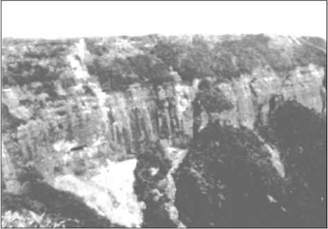
These spatial variations have brought in elements of diversity in the relief of the Peninsular plateau. The northwestern part of the plateau has a complex relief of ravines and gorges. The ravines (Ravines are formed by deep erosive action of water on the alluvial soil. The ravines in Chambal Valley are massive up to 10 metre deep and 30 metre high. Ravines in the Chambal are hundreds of thousands of years old.) of Chambal, Bhind and Morena are some of the well-known examples.
 |
| The ravine of Chambal |
On the basis of the prominent relief features, the Peninsular plateau can be divided into three broad groups:
(i) The Deccan Plateau
(ii) The Central Highlands
(iii) The Northeastern Plateau.
The Deccan Plateau
This is bordered by the Western Ghats in the west, Eastern Ghats in the east and the Satpura, Maikal range and Mahadeo hills in the north.
.png)
Western Ghats are locally known by different names such as Sahyadri in Maharashtra, Nilgiri hills in Karnataka and Tamil Nadu and Anaimalai hills and Cardamom hills in Kerala.
Western Ghats are comparatively higher in elevation and more continuous than the Eastern Ghats. Their average elevation is about 1,500 m with the height increasing from north to south. ‘Anaimudi’ (2,695 m), the highest peak of Peninsular plateau is located on the Anaimalai hills of the Western Ghats followed by Doddabetta peak (2,637 m) on the Nilgiri hills.
 |
| Anaimudi Peak, the highest peak of Peninsular India |
,%20the%20Second%20highest%20peak%20of%20Peninsular%20plateau%20is%20located%20on%20the%20Nilgiri%20hills..jpg) |
| Doddabetta peak, the Second highest peak of Peninsular India |
Most of the Peninsular rivers have their origin in the Western Ghats.
 |
| The Peninsular rivers |
Eastern Ghats comprising the discontinuous and low hills are highly eroded by the rivers such as the Mahanadi, the Godavari, the Krishna, the Kaveri, etc.
Some of the important ranges include the Javadi hills, the Palconda range, the Nallamala hills, the Mahendragiri hills, etc.
The Eastern and the Western Ghats meet each other at the Nilgiri hills.
 |
| The Javadi hills, the Palconda range, the Nallamala hills, the Mahendragiri hills |
The Central Highlands
They are bounded to the west by the Aravali range. The Satpura range is formed by a series of scarped plateaus on the south, generally at an elevation varying between 600-900 m above the mean sea level. This forms the northernmost boundary of the Deccan plateau. It is a classic example of the relict mountains which are highly denuded and form discontinuous ranges.
 |
| The Central Highlands |
The extension of the Peninsular plateau can be seen as far as Jaisalmer in the West, where it has been covered by the longitudinal sand ridges and crescent-shaped sand dunes called barchans.
 |
| Barchans |
This region has undergone metamorphic processes in its geological history, which can be corroborated by the presence of metamorphic rocks such as marble, slate, gneiss, etc.
The general elevation of the Central Highlands ranges between 700-1,000 m above the mean sea level and it slopes towards the north and northeastern directions. Most of the tributaries of the river Yamuna have their origin in the Vindhyan and Kaimur ranges. Banas is the only significant tributary of the river Chambal that originates from the Aravalli in the west.
 |
| the tributaries of the river Yamuna |
An eastern extension of the Central Highland is formed by the Rajmahal hills, to the south of which lies a large reserve of mineral resources in the Chotanagpur plateau.
 |
| The Rajmahal hills and the Chotanagpur plateau |
The Northeastern Plateau
In fact it is an extension of the main Peninsular plateau. It is believed that due to the force exerted by the northeastward movement of the Indian plate at the time of the Himalayan origin, a huge fault was created between the Rajmahal hills and the Meghalaya plateau. Later, this depression got filled up by the deposition activity of the numerous rivers.
 |
| Garo - Rajmahal Gap and Karbi Anglong plateau |
Today, the Meghalaya and Karbi Anglong plateau stand detached from the main Peninsular Block.
The Meghalaya plateau is further sub-divided into three: (i) The Garo Hills; (ii) The Khasi Hills; (iii) The Jaintia Hills, named after the tribal groups inhabiting this region. An extension of this is also seen in the Karbi Anglong hills of Assam. Similar to the Chotanagpur plateau, the Meghalaya plateau is also rich in mineral resources like coal, iron ore, sillimanite, limestone and uranium.
 |
| Garo-Khasi and Jaintia Hills; The Karbi Anglong hills |
This area receives maximum rainfall from the southwest monsoon. As a result, the Meghalaya plateau has a highly eroded surface. Cherrapunji displays a bare rocky surface devoid of any permanent vegetation cover.
 |
| Cherrapunjee and Mawsynram, the wettest places on earth |
प्रायद्वीपीय पठार
नदियों के मैदान से 150 मीटर ऊँचाई से ऊपर उठता हुआ प्रायद्वीपीय पठार तिकोने आकार वाला कटा-फटा भूखंड है, जिसकी ऊँचाई 600 से 900 मीटर है। उत्तर पश्चिम में दिल्ली, कटक (अरावली विस्तार), पूर्व में राजमहल पहाड़ियाँ, पश्चिम में गिर पहाड़ियाँ और दक्षिण में इलायची (कार्डामम) पहाड़ियाँ, प्रायद्वीप पठार की सीमाएँ निर्धारित करती हैं। उत्तर-पूर्व में शिलांग तथा कार्बी-एेंगलोंग पठार भी इसी भूखंड का विस्तार है।प्रायद्वीपीय भारत अनेक पठारों से मिलकर बना है, जैसे- हजारीबाग पठार, पालायु पठार, रांची पठार, मालवा पठार, कोयेम्बटूर पठार और कर्नाटक पठार। यह भारत के प्राचीनतम और स्थिर भूभागों में से एक है। सामान्य तौर पर प्रायद्वीप की ऊँचाई पश्चिम से पूर्व को कम होती चली जाती है, जिसका प्रमाण यहाँ की नदियों के बहाव की दिशा से भी मिलता है। प्रायद्वीप पठार की कुछ नदियों के नाम बताएँ जो बंगाल की खाड़ी और अरब सागर में गिरती हैं। कुछ स्थलाकृतियों के नाम भी बताएँ जो पूर्व की ओर प्रवाहित नदियों से संबंधित हैं परंतु पश्चिम दिशा में बहने वाली नदियों से संबंधित नहीं है। इस क्षेत्र की मुख्य प्राकृतिक स्थलाकृतियों में टॉर, ब्लॉक पर्वत, भ्रंश घाटियाँ, पर्वत स्कंध, नग्न चट्टान संरचना, टेकरी (hummocky) पहाड़ी शृंखलाएँ और क्वार्ट्जाइट भित्तियाँ (dykes) शामिल हैं जो प्राकृतिक जल संग्रह के स्थल हैं। इस पठार के पश्चिमी और उत्तर-पश्चिमी भाग में मुख्य रूप से काली मिट्टी पाई जाती है।
चित्र 2.10 : उत्तरी मैदान
प्रायद्वीपीय पठार के अनेक हिस्से भू-उत्थान व निमज्जन, भ्रंश तथा विभंग निर्माण प्रक्रिया के अनेक पुनरावर्ती दौर से गुजरे हैं (भीमा भ्रंश का उल्लेख करना आवश्यक है क्योंकि वहाँ बार-बार भूकंपीय हलचलें होती रहतीं हैं) अपनी पुनरावर्ती भूकंपीय क्रियाओं की क्षेत्रीय विभिन्नता के कारण ही प्रायद्वीपीय पठार पर धरातलीय विविधताएँ पाई जाती हैं। इस पठार के उत्तरी-पश्चिमी भाग में नदी खड्ड और महाखड्ड इसके धरातल को जटिल बनाते हैं। चंबल, भिंड और मोरेना खड्ड इसके उदाहरण हैं।
मुख्य उच्चावच लक्षणों के अनुसार प्रायद्वीपीय पठार को तीन भागों में बाँटा जा सकता है।
(i) दक्कन का पठार;
(ii) मध्य उच्च भूभाग;
(iii) उत्तरी-पूर्वी पठार
दक्कन का पठार
इसके पश्चिम में पश्चिमी घाट, पूर्व में पूर्वी घाट और उत्तर में सतपुड़ा, मैकाल और महादेव पहाड़ियाँ हैं। पश्चिमी घाट को स्थानीय तौर पर अनेक नाम दिए गए हैं, जैसे– महाराष्ट्र में सहयाद्रि, कर्नाटक और तमिलनाडु में नीलगिरि और केरल में अनामलाई और इलायची (कार्डामम) पहाड़ियाँ। पूर्वी घाट की तुलना में पश्चिमी घाट ऊँचे और अविरत हैं। इनकी औसत ऊँचाई लगभग 1500 मीटर है, जो कि उत्तर से दक्षिण की तरफ बढ़ती चली जाती है। प्रायद्वीपीय पठार की सबसे ऊँची चोटी अनाईमुडी (2695 मीटर) है, जो पश्चिमी घाट की अनामलाई पहाड़ियों में स्थित है। दूसरी सबसे ऊँची चोटी डोडाबेटा है और यह नीलगिरी पहाड़ियों में है। ज़्यादातर प्रायद्वीपीय नदियों की उत्पत्ति पश्चिमी घाट से है। पूर्वी घाट अविरत नहीं है और महानदी, गोदावरी, कृष्णा और कावेरी नदियों द्वारा अपरदित हैं। यहाँ की कुछ मुख्य श्रेणियाँ जावादी पहाड़ियाँ, पालकोण्डा श्रेणी, नल्लामाला पहाड़ियाँ और महेंद्रगिरि पहाड़ियाँ हैं। पूर्वी और पश्चिमी घाट नीलगिरी पहाड़ियों में आपस में मिलते हैं।
चित्र 2.11 : प्रायद्वीपीय पठार का एक भाग
मध्य उच्च भूभाग
पश्चिम में अरावली पर्वत इसकी सीमा बनाते हैं। इसके दक्षिण में सतपुड़ा पर्वत उच्छिष्ट पठार की श्रेणियों से बना हैं जिनकी समुद्रतल से ऊँचाई 600 से 900 मीटर है। ये दक्कन पठार की उत्तरी सीमा बनाते हैं। ये अवशिष्ट पर्वतों के उत्कृष्ट उदाहरण हैं, जो कि काफी हद तक अपरदित हैं और इनकी शृंखला टूटी हुई है। प्रायद्वीपीय पठार के इस भाग का विस्तार जैसलमेर तक है जहाँ यह अनुदैर्ध्य रेत के टिब्बों और चापाकार (बरखान) रेतीले टिब्बो से ढके हैं। अपने भूगर्भीय इतिहास में यह क्षेत्र कायांतरित प्रक्रियाओं से गुजर चुका है और कायांतरित चट्टानों, जैस-संगमरमर, स्लेट और नाइस की उपस्थिति इसका प्रमाण है।
समुद्र तल से मध्य उच्च भूभाग की ऊँचाई 700 से 1000 मीटर के बीच है और उत्तर तथा उत्तर-पूर्व दिशा में इसकी ऊँचाई कम होती चली जाती है। यमुना की अधिकतर सहायक नदियाँ विंध्याचल और कैमूर श्रेणियों से निकलती हैं। बनास, चंबल की एकमात्र मुख्य सहायक नदी है, जो पश्चिम में अरावली से निकलती है। मध्य उच्च भूभाग का पूर्वी विस्तार राजमहल की पहाड़ियों तक है जिसके दक्षिण में स्थित छोटा नागपुर पठार खनिज पदार्थों का भंडार है।
उत्तर-पूर्व पठार
वास्तव में यह प्रायद्वीपीय पठार का ही एक विस्तारित भाग है। यह माना जाता है कि हिमालय उत्पत्ति के समय इंडियन प्लेट के उत्तर-पूर्व दिशा में खिसकने के कारण, राजमहल पहाड़ियों और मेघालय के पठार के बीच भ्रंश घाटी बनने से यह अलग हो गया था। बाद में यह नदी द्वारा जमा किए जलोढ़ द्वारा पाट दिया गया। आज मेघालय और कार्बी एेंगलोंग पठार इसी कारण से मुख्य प्रायद्वीपीय पठार से अलग-थलग हैं। इसमें आवास करने वाली जनजातियों के नाम के आधार पर मेघालय के पठार को तीन भागों में बाँटा गया है– (i) गारो पहाड़ियाँ (ii) खासी पहाड़ियाँ (iii)जयंतिया पहाड़ियाँ। असम की कार्बी एेंगलोंग पहाड़ियाँ भी इसी का विस्तार है। छोटा नागपुर के पठार की तरह मेघालय के पठार भी कोयला, लोहा, सिलीमेनाइट, चूने के पत्थर और यूरेनियम जैसे खनिज पदार्थों का भंडार है। इस क्षेत्र में अधिकतर वर्षा दक्षिण-पश्चिमी मानसून से होती है। परिणामस्वरूप, मेघालय का पठार एक अति अपरदित भूतल है। चेरापूंजी नग्न चट्टानों से ढका स्थल है और यहाँ वनस्पति लगभग नहीं के बराबर है।
You Can Also Visit...
Map of Indian Physical Divisions and Relief
Physiographic divisions of India भारत के भौगोलिक खंड
The North and Northeastern Mountains उत्तर और उत्तरपूर्वी पर्वत
Regional Classification of the Himalayas हिमालय का प्रादेशिक वर्गीकरण
The Northern Plains उत्तरी मैदान
The Peninsular Plateau प्रायद्वीपीय पठार
The Indian Desert - Thar Desert भारतीय मरुस्थल - थार रेगिस्तान
The Coastal Plains तटीय मैदान
The Islands द्वीपसमूह